Sunday, July 21, 2013

A hot one on the Carrizo, 07/19/13


Some of you may have looked over my recent output and wondered "Where's the other Stillman? The one who hikes?". Believe me, I'm just waiting for rain (somewhat impatiently, I might add). I've got a helluva line-up planned for the fall/winter, and if I can accomplish just some of it you'll have been invited to some interesting and seldom seen country. In other words, when rain come the Stillman go. In the mean time I have (obviously) been spending a lot of time on rock art. What I would like to point out is that getting to these sites often takes more than a little effort, so rest assured I'm not just idling the summer by. Today for instance, I logged about 8 miles on foot in 103 degree heat. That's a bit like work.

My agenda for the day was to see another rock art site, an old ranch, and a couple spring sites. The old ranches of the Carrizo are fascinating places that really put you in the past and as for spring sites, some few have rock art, most do not. Sometimes the curious mind just has to go have a look see. Even if there's no rock art (likely), you may find a pretty place or something else that makes the looking worth the doing. At the minimum it becomes one less curiosity to be satisfied.


Today's rock art site is in a far corner of the Carrizo and required a good deal of cross-country rambling to find. Man, it was hot on the Plain. The air was still, without a breath of wind. Heat shimmers blurred the horizon and the sun cast Soda Lake in a stark glare of blinding white. El Sol beat down in a weird, almost heavy way, desaturating the sky with raw UV. By the time I located the alcove and it's impressive collection of rock art I was drenched head to toe in a dripping bath of my own salts (Sounds sexy, don't it? Not.). I was as grateful for the the alcove's cool shade as I'm sure the folks who painted these pretty pieces were. As with all things Carrizo, this site is pretty remarkable. After a cool down I got to work.


 As I said previously, the ranches of the Carrizo are well worth the time if rusting, falling down old things interest you. Traver Ranch, KCL Ranch, Saucito and others offer a stark look at the difficulties that the independent folks of that time would have lived with daily in order scratch out a living on the Plain. In this case, I found my way over to the Cochora Ranch site on the Elkhorn side of the Plain. This site started out with a natural spring which was developed further with a mill driven water well. A couple hundred yard away are several well shafts indicating the increasing demand for ground water as the area dried up. One old and battered wind mill still stands, rusting in peace. A small shed holds the next and final step in attempting to keep this ranch alive, a diesel engine driven jack pump. It appears that the ranch died a slow and parched death, and today the desert is reclaiming it's own.

Cochora Ranch

Diesel powered pump jack.


Evidence of life and death the Plain can be found with little effort.
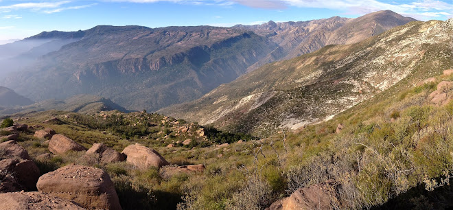
I did quite a bit of driving around the Carrizo, criss-crossing the Plain a few times on old trails leading I knew not where. I ended up roving through a couple canyons, hiking into Lawson Spring and Padrones Spring. In this part of the Carrizo the hilly foothills of the Caliente Range descend to the valley floor, eroding into colorful badlands and washes. There is a collision of two or more types of rock at Padrones and if I knew anything about geology I could tell you more about that. 

Was a good day. Can't wait for things to cool down though. Stand fast, this too shall pass.

Padrones Spring
Link: Native American Art, My Perspective

Tuesday, July 16, 2013

BRMs On Steroids, Bedrock CA


Under an airy canopy of ancient oaks can be found a collection of bench rock mortars (BRMs) par excellence. I haven't ever encountered so many, so big, and so close together. In photo above you'll see that some of the BRMs seem to have been arranged by design, with a bit of artistry in mind. You'll also observe that a recent thunder shower had left a bit of water in these mortars highlighting their secondary use as a catch basin. It's easy to imagine the Chumash covering these holes with woven mats to preserve and protect stored water. The site has all the prerequisites for easy coastal living, access to both the backcountry and coastal region, a reliable water source not too far away, and the kind of forested country that the Chumash preferred. The size and depth of these mortars speak to generations of use. History writ in stone.


Link: Native American Art, My Perspective

Thursday, July 4, 2013

Slide Mountain Lookout, 07/02/13


Because I'm not an overly avid map reader I never really realized that the area around Pyramid Lake belongs to the Angeles National Forest. I always figured that anything west of Interstate 5 was Los Padres. Goes to show what I know.
So this Lookout I'm about to tell you about is part of the Angeles, which maybe explains why it didn't feel like a Los Padres trail, and by that I mean that the route was uncommonly manicured and 100% bloodless.

Supremely skate-able pavement.
I started from the parking area at Frenchman's Flat, which is accessed from Templin Hwy off the I-5. The day starts with about a mile and a half pavement walk, and I have to say that this may just be the smoothest piece of pavement in California, well worth humping in the Sector 9 for. But that's for another day. After a mile or so a bomb-shelter looking thing was visible off to the right and couple minutes later I reached the real trailhead for the walk up Slide Mountain. 

The trailhead is not signed. Hang a left at the Rd/Wht/Blk gate.
I climbed a nicely graded road cut at a moderate angle for a little over a half mile before the road petered down to an equally nice single-track. This trail continued snaking uphill at a remarkably consistent grade until topping out on the shoulder of the summit ridge. Like any good ridge this one offers great views, in this case you get an eyeful of Cobblestone Mountain and a unique glimpse into the Piru Creek drainage. The route climbs the ridge for a bit and then switch-backs up to the summit. Like a lot of these things you don't actually get to see the tower until you're basically underneath it. 

First view of the tower on the way up.

The thing that might surprise those of you who understand that wildfire monitoring now days is done by satellite and drones; this tower and two of her Angeles Nat'l Forest sisters are still manned by volunteers. No shit. The last lookout pulled a couple day shifts just two weeks ago. Yup, learned a couple things that day. For instance, the USFS is accepting applicants to volunteer for fire watch. It sounds like they teach you what you need to know and away you go. For more information on how to volunteer you can visit the Angeles National Forest Lookout Association. The most basic prerequisite is that one be able to make the hike up to the tower ( 1.35miles on rd then 3.65miles and 2775' gain on dirt).

The tower on Slide Mountain is in excellent shape and immaculately kept. Made of galvanized steel and heavy duty glass, this structure was meant to last. The inside of the watch tower is arranged in the same general fashion as many others, with various counters and bunk space laid out around a central map table. The treat here is that one gets to imagine for real what being up here for a while would be like. It looks like a nice gig.


And now I'll get around to the views one would observe from this tower. First and most obvious is a birds eye down onto Pyramid Lake, its dam, and a small islet in the lake that somebody named Chumash Island. I find this ironic because there wasn't an island until the lake was made, and since that time it has not been reported that any Chumash have resided there or live there currently. The cynical side of me wonders if naming this man-made aberration was a gesture at placating those who decried the loss of whatever antiquities might lie under the lake. Cobblestone Mountain Can be seen immediately to the west, and the view down Piru Creek extends all the way to Lake Piru. This is a great place to put a lookout tower. 

The view down Piru Creek all the way to the lake.
Cobblestone.
Cobblestone again.
Pyramid Lake.


To say that I was not amused to find an ExxonMobil pipeline adjacent to Piru Creek would be an understatement.