Sunday, April 24, 2011

Reyes Peak via Chorro Grande Trail, 04/23/2011

I've been up Reyes Peak a number of times, and I've always started at the trailhead at the end of Pine Mountain Road, but I never really felt like I "earned" the summit. It's just too easy from the road, three-ish miles with only about 500ft of gain. Yesterday I earned it.
The Chorro Grande trail takes off from Highway 33 at an unmarked trailhead (2 posts where a sign should be are the marker), at an altitude of 3,400ft. The trail ascends at a moderate angle for a couple miles, climbing through low-land chaparral before the trail abruptly jacks up the steep, and stays that way until reaching Pine Mountain Road at what boulderers call Enlightenment Ridge.
As special word about this three mile "hill". My kindest adjective for this hill would be the word "arduous". I mean, this is right up there with memorable heart-break hills in the Tetons, in the Olympics, the Sierras. It is steep, sustained, arduous.
I blasted through the brutal 5 mile climb from the 33 in 1:50minutes I took a nice break at the last camp on the summit ridge. Patches of snow are still to be found in the shade. The whole ridge felt clean, renewed. The hordes of campers and climbers haven't yet invaded the mountain top. Everything is green. The chalk has been washed away by the winter.

After my break I headed east down the 1.25 miles to the parking lot at the Reyes Peak trailhead and just kept walking right up to the top of Reyes. There are a few steeps in the pines on the way to Reyes, some with snow, but after the grind up Chorro these seem short, almost pleasant. Reyes is a spectacular summit at 7,500ft, notable really for it's 360 vistas. The only direction you can't really see from the summit markers is toward the north, but the views to the north as you descend the peak on your way back are just spectacular. The Cuyama Badlands are quite a sight.


In what seemed like no time I was off Reyes and hooking a left to start the knee-bashing Chorro Grande downhill. It's hard to decide which is worse, the quad-killing uphill or the jackhammer knees on the way down. I can tell you that it's far easier to observe and enjoy the sights on the descent. For instance, I took a nice break at Chorro Grande Camp. This is a comfortable place nestled in a hip of the mountain. It has a clear spring which flows from under a cavernous rock. There are Chumash grinding bowls on camp boulders and the whole place is shaded by pines and oaks. It is a peaceful place and feels very old.


I resumed the knee-bashing descent, most of which provides impressive views up the upper sespe. This is the kind of view that I enjoy traveling through, grand and broad. I could broadly state that my truck seemed grandly far away.
Trip Stats:
Distance: 17 miles round trip
Elevation gained: Over 4,000ft
Time (including breaks): 6hours 20 min

Below: Remains of somebody's bad day, Hwy 33, right above the Snakepits.
Below: Mt Reyes over Piedra Blanca, clouded over as the day grew long.

Tuesday, April 19, 2011

Banged up, hunting for sun, Tar Creek, 04/19/2011

Yesterday I ate shit in a creek, dislocated my my finger in addition to other tissue insults, saw a bobcat, and pissed off a rattlesnake. Today I'm feeling pretty banged up and not into going far or getting hurt in the process. I know I've chastised myself for numerous returns to Tar Creek, and I've recently said that I would be mixing some things up (and I will), but I wasn't feeling very adventurous today so I just sauntered down to the Land of the Lost and parked my butt on a warm rock.
I spent a few hours lazing around at the pools. Completed both the LATimes & NYTimes crosswords, thought about very little of consequence. Not a bad way to pass time, I say.

Monday, April 18, 2011

Lions Canyon Run, 04/18/2011 (a bobcat, a buzzworm, and a busted digit)

What the hell happened to the beautiful, sunny weekend we just had?!? You know, the one that I spent on-call and at work. I got a chance to leave work in the noon hour and bolted out the door, only to be reminded that getting out from under the marine layer would involve some driving.
My first thought was that Matilija might be sunny...wrong! I just kept driving up the 33. The fog and cloud parted at the crest and I drove down into a green and bright Rose Valley. With the limited time I had due to the late hour I opted for a quick circuit of the Lions Canyon and it's east and west fork falls. I took the connector trail that starts just at the entrance to the Rose Valley campground.
West Fork Falls, Lion Creek (above)
I remembered why I liked the connector trail. I takes you up over a ridge and down into Lions Canyon. It's an interesting and varied trail and right now is the time to see it. All the little watercourses are streaming and everything is green.
The West Fork falls are kind of fun to get to. Taking the creek upstream from the WFork camp is pretty and shaded. There are a bunch of old sycamores just before this neat 12 foot falls. Of the 2, the West Fork feels a bit more remote.
I was leaving the falls when I messed up and crashed head-first down some largish rocks into the creek. Yeah, I ate shit. Bashed my knee pretty good. When I could stand and knew that the knee would hold weight, I addressed a corona of pain blossoming in my right hand. I realized that, not only was my right pinky finger not working, but it was also facing the wrong direction. Without giving myself a lot of time to think about what I was doing, I grabbed that digit and yanked hard, added a twist at the end, and felt it pop back into place. A few minutes later I headed over to the East Fork.
The East Fork is more of a collection of waterfalls, most of them less than 10 feet in height, and did I say pretty? Yes, this is a very pretty place and well worth visiting. I think I was 11 years old the first time I saw these falls. It's funny how I forgot how much I like this hike.
A couple other interesting things occurred in addition to the manual, on-site dislocated finger reduction. I pissed off my first rattler of the season. He was in the brush and grass a few inches from the trail and the warning buzz convinced me not to investigate. And to put nice little bow on the day, I spooked a healthy bobcat who had been hiding under a tree full of chirping birds. I guess I wrecked his shot at an early evening snack. All in all, it became a very eventful unplanned afternoon. The 6 mile hike took me 2:45 minutes with stops at both falls. And yes, the finger hurts like hell.
Below: a fat & happy horned toad

Wednesday, April 13, 2011

Tar Creek 04/13/2011


12/10/13: The US Forest Service will be enforcing access restrictions to Tar Creek soon. TC is part of the Condor Sanctuary established as critical habitat to this endangered bird and other wildlife. Epic numbers of visitors, and the trash and graffiti they have left behind, has led to the acknowledgment by the Forest Service that access must be curtailed and enforced. For more information on the impending action visit: Tar Creek Closure.

Back to Tar Creek. It seems to be my year to tour-guide Tar, and that's okay with me. It's always a little bit new to me. Jack Clayton, one of the X-ray gurus in the department where I work, all-round good guy, accompanied me yesterday. I've been trying to get him down Tar for about a year but he had a knee surgery a few months ago and we've been waiting for it to get better. Finally the day comes and wouldn't it just have to be over cast, cool, and generally un-ideal.
The day started with us chasing a couple deer up Goodenough Road. The morning was pretty boisterous, birds everywhere, bunnies, squirrels. No Condors down at the bottom of the canyon though. The water level remains high and the pools look like they'll be in good shape well into the summer. The "trail" from the Land of the Lost down to the bottom is getting overgrown with brush and some poison oak now grows in a couple strategic places, as if waiting for an unwary victim.
Jack (and Jack's knee) did just fine and we had a great day, though I was cursing the weatherman for his maladjusted prognostication (the clouds were supposed to be out and gone by noon ("Damn you, Josh Rubenstein of Channel 2!"). I had been looking forward to some sun. We'll just have to get back down there on a nicer day. By the way, I know this hike is like a broken record for me and I will be mixing it up in the coming weeks. Maybe I'll throw in a couple old hikes that would be new to the blog. Take care, enjoy the pics, see you out there.

Sunday, April 10, 2011

Hines Peak/Topatopa Bluff, 04/09/11

How about a long hike in decidedly un-April like conditions? Cliff and I hiked the Sesar>Hines>Topa>Sesar 22 miler on a day that ranged in temperature from 25-55 degrees (depending on where the clouds & wind were), half of that time spent travelling on snow. We got going at 06:45 and rushed through the cold, early miles. The sunrise cast a silver haze on the frosted brush. The creek is high and we heard a chilly roar as we passed above White Ledge falls. We had reached the snow by the the time we passed the picnic bench on the ridge.
We trudged through the long miles, sometimes in shade, sometimes in sun, always on snow until we finally stood at the foot of Hines Peak's steep summit ridge. I sensed that Cliff was a bit apprehensive about the angle of the ridge in relation to the amount of snow. In other words, I think he was wondering how much risk this would entail. I remember having the same sort of feeling a long time ago when I was less familiar with climbing on snow. I threw on my Yaktrax and assured him that we'd make the top. After all, we weren't contending with black clouds, atomic lightning, or flesh eating wind, all of which conditions could have been present.
We quickly opened the Mountaineering 101 Handbook to the chapter on "cutting steps" with excerpts from "understanding your trekking poles" and "basic rockaneering". I cut the steps and Cliff did just fine following in my steps. He got through some of the rocky and exposed stuff without difficulty. He was wall to wall grins on the summit. It was a good summit and a good climb on a cold and breezy day. The down climb went smoothly and we headed back towards Topa Topa which was obscured by clouds.
*Hines is definitely Class III in real snow conditions. Class III can be described as "scrambling with the opportunity to really hurt yourself".


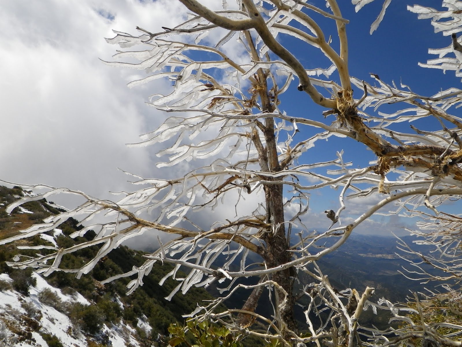
We rolled over to Topa, stopping for a good sit at the saddle junction before facing the last big "Up" of the day. As we approached the summit of Topa we beheld a strange phenomena: fins of ice clinging to manzanita. Clearly, the cloud bank roiling by just a hundred feet from us had receded just minutes ago. Very neat.

As for the summit of Topa, that weird occurrence with the clouds butting up against the bluffs that I've mentioned before was in full effect. It wasn't the kind of day to linger. Down we went and a couple hours later rambled back to the truck.

Let me take a moment to share with you a new found hope for an ambulatory and active future. The inspiration for this brain-bulb comes from hiking with these really great older guys. I ran into Rick Bartell, a friend in his early 60's, on the Arroyo Verde trail. He was charging up some sick hill right beside me. And how about a tip of the hat to Mr. Cliff Griffiths, electrician of the first order, 59 years old, and can hike 22 miles, climb up an icy summit, etc... and be able to do again next weekend. How's that for tough.