Time to tick another one off the list, Cobblestone Mountain. For a guy who doesn't really classify himself as a "peakbagger" I sure seem to end up standing on top of a lot of mountains. For today's mission I was joined by Nico, a frequent commentator on this blog and a connoisseur of our local backcountry. This was our first time out as a team, a "getting to know you" trek. In the end, it was rough, hot, and prickly, but for all that, a supremely satisfying day.
 |
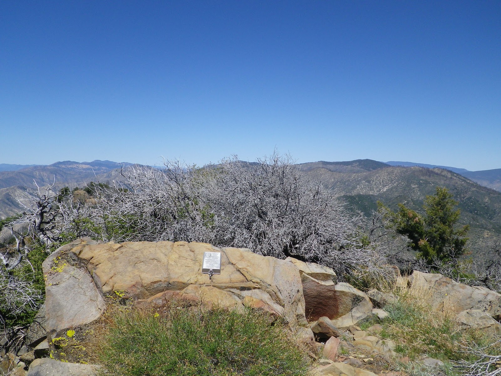
| That's Cobblestone Mountain behind the sign. |
Cobblestone Mountain is one of the more remote and challenging peaks in the Southern Los Padres (SLP). Tackling this peak is all-around difficult, starting with the drive to the trailhead. Nico and I met at my place in Ventura at 04:15, piled in the truck and sucked down coffee all the way up I-5 to the Gorman exit. We followed Gold Hill Rd through the Hungry Valley OHV area and eventually made our way up Alamo Mountain where the Buck Creek trailhead takes off. We made sure not to park in the handicapped slot at the end of this 17 mile 4WD road.
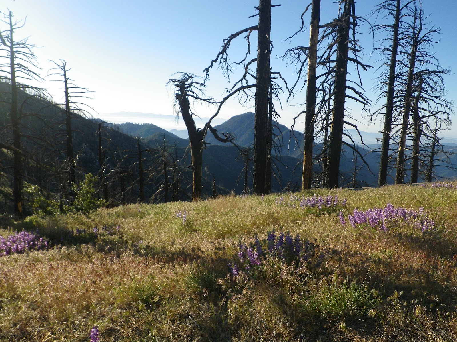
The views from the parking area are impressive. I gazed east into the rising sun at the endlessly undulating White Mountain Ridge. Looming huge in the distance stood Cobblestone, an alarmingly large mountain. I could tell right then and there that we were in for it. It's rare to start a hike from a point at which you can visualize the majority of your route, and the more I looked at this ridge and that peak the harder it looked. Cobblestone has presence.

We set off with the sun in our eyes, treading through golden grasses blushed by lupine, the shattered limbs of deadfall trees silhouetted by the rising sun. We didn't have much of a trail, even from the outset. We followed intermittent single track for a while, diverting frequently to skirt around countless fallen trees. This area had burned during the
2006 Day Fire and as we passed through blackened stands of lifeless pines I realized that only the south facing slopes of this east-west ridge had burned. I noted that the trail was really just a path within a bulldozer track now grown over. Within a mile we were approaching Sewart Mountain, which is at roughly the same elevation as the parking lot. On Sewart's bald summit is a small crag of granite in which we discovered yet another rotting and saturated summit log ( I refer to
Haddock Peak).
 |
| A graveyard of giants. |
 |
| ESE to White Mtn Ridge and Cobblestone Mtn, from Sewart. |
Leaving Sewart our route began to descend sharply toward Buck Creek. This downhill grade is a beau coupe bummer, steep and brushy, characterized by fallen trees and over a thousand feet of elevation loss. Periodically the trail would evaporate into a huge patch of ceanothus or poodle-dog plant. We soon reached an unmarked junction between those peaks to the north (Snowy Pk and Black Mtn) and the ones on our agenda. At this point we stashed a good amount of water before traversing through a hellish expanse of overgrown ridge. In the case of this hike, what goes down must come up, and as we climbed out of the brush we became properly introduced to White Mountain Ridge.
 |
| Buck Creek Canyon, which clearly did not burn in 2006. |
 |
| Interesting succulent, they were sparsely scattered across just the saddle between White Mtn Ridge and Cobblestone. |
The nature of this route can be reduced to descending and re-ascending things in thousand foot increments. Nico and I understood all this going in, but I'll admit that I was impressed with the difficulty of the over-all day. While fighting with brush and struggling up frequent grades wasn't any fun at all, the rugged views and a cool breeze smoothed things out. We finally ascended White Mountain Ridge to a point directly north of Cobblestone. A thousand feet below us lay a narrow saddle which connects our ridge with Cobblestone. Just getting to the saddle below, and then ascending 1,500 feet up Cobblestone to the summit would be tough enough, not to mention the return trip. Somewhere in here the day got sporty.
 |
| At the saddle between White Mtn Ridge and Cobblestone. |
The descent from White Mtn Ridge to the saddle was ugly. There is no trail and the best path of descent is to proceed straight down. This portion of the route is about 45 degrees steep, loose, and avoiding the profusion of prickly plants is impossible. I ended up tearing a new pair of Columbias and pulling several yucca spines out of my leg (I found 5 more in the shower that evening).. Above me I could hear Nico dealing with the same discomforts. Finally we stood on the saddle which separates Fish Creek to the east and Agua Blanca creek to the west, with Cobblestone in our faces and the escape route up to White Mtn Ridge at our backs. Time to get to work.
 |
| Nico, grinding up Cobblestone. |
Though long and steep, the route up to the summit of Cobblestone was obvious...do not look for trail, just go straight up from the saddle. This climb of roughly 1,500 feet is pretty straightforward and I didn't find it to be all that difficult. Nico stuck with me the whole way up and we hit the summit together. The view from Cobblestone is grand, expansive, and unique. All the peaks of the SLP are visible from this summit. On the summit itself is an aluminum Sierra Club summit log of the type seen on many Sierra peaks. To put Cobblestone's isolated remoteness into context, the summit journal was last dated in December of 2011, and summit entries date back as far as the mid 1980's. This peak sees little traffic.
 |
| White Mountain Ridge, Black Mountain in the rear, from Cobblestone. |
 |
| Left to right: Mt Sewart, Snowy Peak, Black Mtn, White Mtn. Mt Pinos in the distance. |
 |
| Nico, reading old summit entries on Cobblestone. |
 |
| Cobblestone's summit register honoring Jack Cross. |

 |
| White Mountain Ridge, taken while descending Cobblestone. |
Nico and I spent 40 minutes atop Cobblestone, each consumed with our own summit rituals. Rested, we turned down Cobblestone and descended back to the saddle. The climb from the saddle up to White Mountain Ridge is the toughest portion of this long and strenuous route, nothing comes easy. This 1,00ft climb is impossible to accomplish without getting scratched up by brush and tagged by yuccas. In addition to that unpleasantness, this 40 degree uphill is fully exposed to the noon sun. Frankly, this climb out of the Cobblestone Saddle sucks. I was pretty happy to regain the ridge above, with it's grassy shade and cool breeze. We took a decent break in the shadow of some pines, assessed our water situation which was right on the margins of barely enough, and proceeded to move east toward the summit of White Mountain .
 |
| Nico, staring at the hardest climb of the day, back from Cobblestone and up to White Mtn Ridge. There is no trail and the best approach is straight up. |
 |
| White Mountain Ridge is very pretty, well worth the hike. |
 |
| Enjoying a nice view during a time-out. |
 |
| Nico, consulting the oracle. |
I really enjoyed this portion of the day, the trip over to White. What path remains travels over several small small hillocks and through a couple sections of brush, but the route is high and grassy with pines and 360 views. After a bit of this rambling we bashed through a last bit of brush to arrive on the summit of White Mountain (Los Padres), which is remarkably similar to the summit of Hines Pk in that it is a collection of sticks and stones with a coffee can register. There is no USGS marker and the last entry in the summit log was dated October 2011. We were getting skosh on water levels and Nico, especially, was getting concerned. I admit that I was getting down to not wanting to know what was left in my reservoir but knew I'd be alright. Nico, on the other hand, made sure to let me know that he overheats fairly easily. He'd started with an appropriate amount of water but I could tell that he was struggling with the heat, which I'd say was at least in the upper 80's. I kept a pretty good eye on him as we started our return trip.
 |
| White Mountain's summit register. There is no USGS marker. |
 |
| Skeletons of the Forest. |
We reversed our course from White Mountain and headed west on this remarkable ridge. I ended up putting Nico in front for much of this stretch, letting him set a pace he could live with. After a while I was noticing some subtle indications that he was headed for trouble. Though most of this ridge is wide open, some sections are brushy and route finding in these areas is problematic. About the third time Nico steered us the wrong way I took over the lead, but kept our pace slow. I also curtailed my water intake in case he ended up needing mine. I knew I'd be fine but was a bit worried about Nico. The guy is built like an ox, but in this heat his gait was getting sloppy and he was flushed, panting. We slowed it way down when the White Mtn Ridge ceded to the flank of Sewart Mtn. We reached our water cache, four liters of the stuff, none too soon.
 |
| Me, Cobblestone Mountain. |

 |
| Nico, headed west on White Mtn ridge. |
 |
| Nico, navigating an area of deadfalls. |
 |
| Skeleton Forest. |
Upon reaching the water stash I gave Nico about 400cc's of gatoraid and we went through a good portion of the rest of it. After a few minutes we got going again, but I still kept the pace slow for the climb up Sewart and the last mile to the truck. Nico was looking quite a bit better by the time we rolled past Sewart and was back to normal by the time we hit the truck.
 |
| Old ammo, dropped a long time ago. Remington 700 Mag |
So, the first time out with Nico had it's issues but he's the first to admit that he doesn't do real well in the heat. Aside from that he is solid, experienced, and generally knows what he's about. We're headed out again this coming weekend but this trip is on the water so we should be good.
As for the day, I give Cobblestone high marks for the toughness of the climb and it's remote location. The views from the summit are remarkable, unique. My favorite portion of this route is the White Mtn Ridge, which is reminiscent of Reyes Peak Ridge and other high and piney parts of our region. I'd like to come back to the area and tag a few of the other near-by peaks, but I think it'll have to wait until things cool down. All in all, this is a tough one, nothing for free.
Nico figured out the math on our route:
13-14 miles
6-7,000 feet of elevation gain
roughly 10 hours (too long, but a good day)
 |
| Nico, headed for home. |
To see me dig a festering Cobblestone yucca needle out of my knee (and do a somewhat professional job at it)
click this link


Another great write-up, DS, and a great trip ... though we oxen of the southern Los Padres would have left that one for cooler days!
ReplyDeleteAs for Buck Creek, it actually did get torched, but its recovery has been insane. Unlike Sewart which remains a graveyard of trees, Buck Creek is a six-foot hedge of ridiculously healthy growth. We did that trip last summer as part of a trio of ill-advised scorchers (along with the Riddler and Sierra Madre Ridge); see http://www.craigrcarey.net/2011/07/veni-vidi-ambuli-buck-creek/ for the write-up.
See you out there!
Did you happen to scope the terrain down to halfway spring? If so, does it look doable?
ReplyDeleteBagging Cobblestone as my first joint effort with Stillman was like trial by fire... The guy loves his big climbs and big miles. I was hoping to not drag him down and was concerned going into this about the potential for high heat (my hiking nemesis). As it turned out, the heat and the tiring effects of a lingering head cold sapped my energy and just about did me in! I had to slow things waaaaay down to a trudge for the climb back to our water cache. Thinking much about the proper route wasn't a concern any longer. My mind was wholly consumed with thoughts of our water caches. It was brutal!
ReplyDeleteAll that said, having the chance to finally stand atop Cobblestone was amazing. The hike to there and back is a worthy challenge and the views were far-reaching and spectacular. And White Mountain Ridge was beautiful and a downright pleasant place to have a break and relax in the shade(although the peak itself is underwhelming).
The big challenge with this area other than the long approach drive, the brushy conditions, the 1000'+ elevation changes and the extreme heat for much of the year, is the lack of reliable water sources. There's a spring near the summit of Cobblestone but an entry in the register suggested it's not much more than a weak seep. The pond that shows up on the topo at the Buck Creek/White Mountain junction was bone dry. The headwaters of the various drainages like Fish Creek didn't feature any nearby obvious springs called out on the topo maps either. If you ran out of water in the area and were in a bad way, you'd have to drop down into the Buck Creek drainage and hope for water farther downstream, otherwise you'd be SOL.
- Nico
@ Coyote Dave...
ReplyDeleteI've often wondered about the historic route from Piru Creek to Cobblestone and the Halfway Spring site along the way. I didn't bother to check the possibilities for a route to Halfway Spring after reading about the poor quality of the Cobblestone Spring. The prospects of taking on that hike and not finding water at Halfway Spring and/or Cobblestone left me a bit discouraged from taking on this adventure. Having been to Ellis Apiary at the mouth of Turtle Canyon a couple of times as well, I have yet to spot any indication of the old route to Halfway Spring from below (although admittedly, I didn't spend much time looking for it either). The mystery continues...
-Nico
We did this hike in October around 10 years ago. On top we were in a cloud, cold and sweaty with no view!
ReplyDeleteNo fair! Like you say, the hike back is tough, way too much uphill after climbing a peak.
Later one fine, warm, clear January day I hiked Buck Creek to White Mtn. and got bit by a tick on top.
I also scouted for the route from Piru a while back and didn't find anything.
Cobblestone hard. Cobblestone hurt.
ReplyDeleteCame across your blog while looking for some info on North Pal via U-Notch and noticed you had a lot of peak write ups out of the Los Padres area. I have come across a few books mentioning Cobblestone and how tough it is coming out of Piru Creek, did not even realize there was an approach from Buck Creek TH. Great report!
ReplyDeleteHaving done two through hikes down the middle section of Piru Creek (Frenchman's Flat to Piru Lake) I have never seen water running down Fish Creek and very little coming down Aqua Blanca and could only imagine how dry the other surrounding creeks would be.
Keep the reports coming!
I've looked at Cobblestone peak every day on my drive to work (near Castaic) for years. It is a beautiful peak that stands out from the ridge line and just calls out to me with a taunting "I'm something special, unique in these parts."
ReplyDeleteI didn't even know it's name until today. Your write-up is fantastic, and makes me want to tackle it even more, but also drives home how foolish attempting to do so would be for someone with my skill and fiteness levels.
I guess I'll just have to enjoy it vicariously through yours and Nico's experience. Thanks for the journey.
In my opinion Cobblestone is the biggest, baddest customer in our forest. Interestingly, I may be back up there in a couple weeks. We'll see how it goes. -DS
ReplyDeleteI agree with David. Cobblestone is mental! If you are taking the Hard Luck Road/ Buck Creek route, Buck Creek trail is probably the hardest part, that trail is an abomination! Is not really a trail in my opinion. Its the second hardest hike I have ever done in my life (the first being Agung in Bali). Here is my GPX file:
ReplyDeletehttp://ridewithgps.com/routes/6565508
As you can see I did not find much of the trail after Buck Creek Camp (not really a formal backcountry camp either). I pretty much was off trail in that section going both ways. I wonder where the trail is there? I was the 5th to reach the summit in 2014. There is no pen at the register by the way. Can someone please bring a pen and leave it there?
Just sticking to Los Padres NF, I believe these peaks also give Cobblestone a run for its money:
Hines Peak
Maldulce
Cone Peak
Erin,
DeleteIf you really want to kill yourself look up "Redrum Ridge"/Cobblestone. Also, Nobody (to my knowledge) has repeated either Topatopa Peak via the ridge, Devils Heart Peak, or White Ledge Peak, all of which make Madulce seem like a stoll in the cedars. Oh yeah, try Samon sometime too.
-DS