Monday, November 19, 2012

Samon Peak... I think? I'll explain. 11/16/12

Evening in Cuyama Valley

Okay, well here's a weird one. I thought I had summited Samon Peak while out and about last Friday. The GPS said I did, and I believe it, but by that time I was so deep in a cloud that I couldn't find the summit marker or the register. And that's the sucky truth. I'm not at all confused about where I was, just that I didn't, as they say, get the t-shirt. Aside from that I had a very nice 25 mile day in the rain.

Madulce Ridge with the summit lost in the clouds.


A sunrise laser beam aimed at Madulce Peak

When I took to the hills on Thursday evening I was well aware that the forecast was not favorable for the type of day that I had planned on. I decided instead to take a crack at Samon Peak. To that end I pre-positioned myself up Santa Barbara Canyon for an early morning start. I parked at Willow Flat instead of at the eastern gate for Buckhorn Rd. Willow Flat is a lot like Grassy Flat on the Sespe in one respect...the names are no longer relevant. See, Grassy Flat is neither grassy nor flat, and Willow Flat has only a nappy old juniper tree. I guess things change. Anyway, I parked it here instead of another half mile up the road in case I decided to link Samon with Madulce and come out through SB Canyon. It didn't work out that way but whatever, I had a great day.

Here's the "meadow" that's mentioned in route directions for Samon Peak.
I crawled into the bed of the truck and knocked out early under cloudy skies. When I woke at 0300 the first thing I noticed after killing the alarm clock was the rain. Oh good. Crawling out of a warm bag and into shell gear at 3AM isn't anything new for me, but I'd rather it was snowing. I have a feline nature and part of that is an antipathy for being cold and wet. I don't enjoy those two things when combined. And especially without coffee. Already 2 strikes on the day. No coffee to be had so it was Go Go Gadget Gore-Tex! time. I got myself put together pretty quickly and was out the gate at 0330. In the rain.


It was a black morning. And did I mention it was raining? After a mile of chasing the beam from the headlamp I was pretty warmed up and feeling about right. I hit the gas and started trucking up Buckhorn Rd. This road is one of those routes that I prefer doing in the dark. The road is smooth and foot friendly with very few rocks, which makes for easy walking. Also, it's just better to not be able to see how steep the first five miles are and how far away the various loops in the road are. I have heard that this long and tedious grade can be bad for morale. I know this route pretty well and I let the miles fall by while listening to the rain fall on my hood. It was a peaceful walk, quiet. I enjoyed the climb for what it was.

Anybody know anything about an old telegraph? wire strung on the high south shoulder of Samon Peak?
At the top of the grade I headed south, following Buckhorn Rd. The sky began to lighten in the east but overhead was a solid ceiling of ominous clouds coming in from the west. Now that I was up above the canyons I was greeted by a persistent northerly breeze that came on at 10-15mph and never seemed to go away. The wind and the rain seemed to get along like old friends, lucky me. At sunrise the first rays of light cut a straight line under the cloud ceiling which was a neat, if too brief show. Soon enough the sun was behind the clouds and my day returned to dripping grey. As I neared Chokecherry Spring I started keeping an eye out for the use trail which leads to the summit of Samon. That junction is currently marked by twin yellow hazard tapes, 1-2/10's of a mile north of the spring.


I couldn't make out much from the start of the summit trail. The clouds ceiling was now less that a hundred feet above my head. Wind, rain, and pretty soon I'd be up in that cloud. How damn exciting is that? Up I went. The lowest portion of the summit trail ascends the northern side of the ravine that drains to Chokecherry Spring. After a brief, steep and brushy climb I traversed WNW across the small meadow that's mentioned in all the guides, and continued climbing the route up the NW side of the ridge. So far so good. I was soon in the clouds, drenched on the outside, breathing water, huffing up this steep and muddy track. I finally popped out on a high saddle with one arm of the ridge heading south and the summit ridge a short ways up and right. I waded through the cloud until I ran out of places to go up, and this might have been a little comical to an outside observer. I wandered all over the top of that thing, looking everywhere for the marker, but the cloud was so thick that I couldn't see more than a foot or two. As I mentioned above, the GPS said I was there. What I remember of the summit (and I fully expect to be told by some of you that I may or may not have actually been there) is a rocky pile of broken brown rock, about 8 feet on a side. West of that pile, and down hill about 15 feet is a second, smaller pile of the same rock. If this ain't the top of Samon Peak then I need a new GPS.

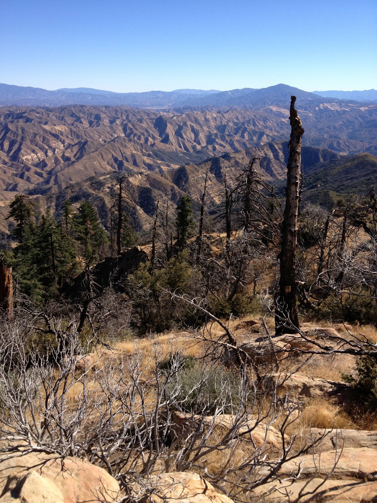
Samon Peak. I was somewhere up in that mess.
Buckhorn Road.
Buckhorn Road.
Buckhorn Road.
 
After wandering around in the cloud a bit I headed over to the south pointing shoulder I mentioned before. I followed a bear track out that way for a while, and was surprised to find the old wire and glass insulators strung along the ridgeline's length. As for the summit, I'm completely comfortable with the idea that I have to go back in better conditions. I liked the peak but I just couldn't find the marker in all that cloud.

I abandoned the peak and descended back to Buckhorn, hit the gas and got outa there. From below the clouds I could see patches of sunlight to the north. That's where I wanted to be...out of the rain dammit. I just rolled on out to the long grade back into SB Canyon and the end of the day. I had a great time out there despite the weather. Some days are just wet and windy and you can't do anything about it except stay home. I guess I'm not that guy.

I figured my exertions at around 25 miles for the day, which took me 10 hours to accomplish. I'll be back to sign that summit, next time I'll wait for a clear day.


Sunday, November 18, 2012

At large in the SLP, 11/09/12


Last week I ran up a canyon that I will leave unnamed. This was a little reconnaissance for some thing bigger. I wanted to see "things" from several different angles. While I was out and about I startled a few deer, spooked a harris hawk out of the brush, and oh yeah, found this little gift from the big birds above. This feather measured just over 18 inches. Big. And that's about all I have that I'm gonna share about that day. 


Wednesday, November 7, 2012

Madulce Peak via Santa Barbara Canyon, 11/05/12

Here's the trip stats for doing Madulce Peak as a day-hike via Santa Barbara Canyon (I'll get to the rest of it in a minute):
Started from Willow Flat: 04:15, ended at 15:15. 
Time to summit: 5:40
Total time: 11:00
Elevation Gain: > 4,000 ft of unmaintained trail
Total Distance: 22.5 miles

Waking up at 2AM isn't any fun at all, but I had to do it. I needed an early jump on a long trail day, and it takes two hours to get to Santa Barbara Canyon from Ventura. Coffee in one hand and the other on the wheel I roll up Highway 33. I was bleary eyed and sleepy until I almost pasted a 3-point buck at Wheeler. It was close. Not so sleepy after that.

When I stepped out of the truck I was immediately taken with the crystalline skies. Dark black, pierced by glittering stars and hung with a half moon. A beautiful morning for miles. 

A look back down Santa Barbara Canyon.
Santa Barbara Canyon is not a new trail for me. I went through there recently and remarked at that time that the trail was brushy and can be tricky in a couple spots, but the route to Madulce Station was pretty easy to follow. Nothing has changed in that regard. Travelling up this canyon is best done quickly. Most of the route is close and overgrown, denying the hiker any real views. It's not all that pretty anyway. The canyon is full of wild rose, sage, manzanita and miscellaneous chaparral. There are a handfull of nice places to pull out along the way, mostly through the forested portions. This canyon is dry as a bone at this time. For older trip report (Santa Barbara Cnyn/Upper Sisquoc/Judell Cnyn).

Eventually the canyon terminates in a short but steep climb which has been labeled "heart break hill" by Conant on his map of the region. This climb does have one interesting feature in that the hiker ascends what is basically a knee-deep gully for a time. Beware of "sucker trails", paths that have been created by animals and immortalized by people taking said path in error, or in hope of an easier way up this grade. Several of these sucker trails deviate from the real route. Just assume when going up this hill that you should just keep going up until there isn't any more up. 

Taken about 5 minutes out from Madulce Station.
I rolled into Madulce Station at 7AM, just in time for breakfast! I sat in the sun for a few minutes nibbling on mandarins, just enjoying myself. The best campsite here is actually a couple hundred yards further up the trail toward the peak. I would have taken my break there but that site doesn't get any morning sun. There is no water in the creek at Madulce right now. The old spring box against the hill has been demolished and seems to have become a bear wallow. I got going again after a half hour.

The sign at Madulce Station, which points you...

...directly into this. And the best part is, the sign is right.

As you can see from the pictures above, the road up Madulce from the Station is the road less travelled. The first mile up from the Station is pretty brushy, and some people have reported route finding issues. Eventually the trail climbs west out of the Madulce drainage, taking the north side of the creek. This portion of the route cuts through fire damaged area and deadfall trees criss-cross much of the trail. Another mile of climbing through charred cedars leads to a shady junction marked by a good old-fashioned fireproof sign which seldom points in the right direction. Here's where I was was finally going to get a taste of the unknown, the last two miles over to the summit.

The trail forks high on Madulce, east (left) to the peak, and west (right) to Alamar Saddle.

"Over" to the summit might seem confusing but that's the way of it. This final leg to the summit traverses back east across the north side of Madulce, gradually losing 300-400 feet of hard earned elevation for the first mile. The final 8/10ths of a mile are pretty tough, earning all that lost footage back plus more. Route finding on this last leg to the summit can be an issue. The route is fairly well marked with trail ducks and survey tape but the actual trail is a mess. The trail is seldom more than a foot wide path of slightly tamped pine needles. There are several washed out sections and many deadfalls to contend with. I mentioned sucker trails before, they are quite prevalent on this last step to the top. This route has a number of switchbacks that are just as vague and indistinct as the rest of the trail. Animals and hikers have zigged right past the zag and ended up heading some direction that doesn't necessarily get you where you want to go. It pays to be awake and aware during this part. Also, I found that staying on route while descending was a bit more difficult than on the up, for some reason. Anyway, staying on route requires some diligence.

A view northeast toward Cuyama Peak.

I summited 5h:40min after starting from Willow Flat, and what a view. And what a great peak. This summit is way worth doing. It's out in the sticks, and on a day like I had the views are pretty wild. Views of all the Channel Islands, Pine Mountain Ridge, Don Victor Valley, Alamar and Samon Peak. Views down into the Dick Smith and San Rafael. This peak used to have a fire lookout on top and all that remains are the base pillars and a couple slabs of concrete. I spent an hour on top, enjoying the morning and brunch with a view.

Madulce Summit.

A view west toward Santa Barbara.
ENE to Cuyama Peak.
ESE toward Reyes.
Madulce Peak Summit Register.
Looking west to Alamar Saddle and Samon Peak.


Thank you Zaca Fire.
Break time in the shade at the high junction.

Eventually it was time to get on my way down. As I mentioned, descending back to the high junction on the north side of Madulce can be tricky. I got that all straightened out, took a break at the sign and got back on my way. I pretty much blew out the rest of the way to the truck in one big sprint. Below are a collection of shots I took on the return route that should shed some light on the nature of this trail.


Somewhere in the day I encountered the skeletonized remains of a small bear. All that was left of the poor critter was a scattering of bones and brown hair. The scavengers had done their job well. It was impossible to speculate on the cause of death.

Bear remains.


This hike was a really nice day, and the peak was a fun and engaging climb. I'm glad that after walking by the turnoff for the peak four times previously I was finally able to dedicate some time to just doing the peak. It turned out to be a great day.

Below: this one's for you, Chris ( he comments on this blog fairly frequently). How'd you like the Upper Sisquoc?


Thursday, November 1, 2012

Topatopa Peak Fire Lookout from Hines Peak [SVS], 10/30/12

I have a new standard by which all of the Los Padres' evils may be measured. The seven miles from Hines Peak to Topatopa Peak are, and I've thought about the right words here, a cast iron bitch. I think I need an intervention. I keep doing things that people don't do, and getting away with it. Twenty miles round-trip, 14 of it cross-country. Fourteen hours. Solo. Deep into the blackest heart of the coastal backcountry.

Before we get any further with this I need to admit to you readers that I don't want you to do this hike. I don't ever really exaggerate or embellish when I describe the difficulties of any given hike, and I will not do so now. This ridge is bad news. It is really and truly Egypt. A bad day here could have very serious consequences. I just don't think that anybody else should do this route in a day. It's too long and way too far out there. It's a scary place, one not meant for human beings. Should somebody one day try to repeat this route, I would advise you bring an over-dose of masochism and more water than you've ever carried. And bring some Kleenex because you will want to cry. It's that hard.
Here's the route starting from the eastern end of Nordoff Ridge Rd.

I spent my on-call weekend (when I wasn't at the hospital) poring over Google Earth and NatGeo Maps, parsing a long and benignly pixelated ridge. I can already tell that the satellite imagery is several years out of date, probably five or so years. The imagery shows very recent burn area from the 2006 Day Fire. So I can anticipate far more brush than the intel would suggest. There are no springs, no water of any kind on Topatopa Ridge. I can rest assured that there will be many, many brutal climbs and reciprocal losses of elevation. There will be brush and blood. There will be sweat and dirt and miles of fire-charred manzanita. Every step will be a small victory. I actually get the jitters 2 nights before I take off for this one. I don't get the jitters anymore. My subconscious is telling me to take this one seriously. I listen: map, compass, GPS, SPOT, extra batteries, calories, a great big knife, .40 cal, 6 liters of water and perverse sense of "fun".

Ojai and Lake casitas from atop the Nordoff Fire Tower.
I started this trek by swinging by the USFS office in Ojai to pick up a permit and the gate combo to Nordoff Ridge Rd. Papers in order it was time to drop into 4-wheel and head up the mountain. The little campsite on the ridge with the bench and fire pit was occupied by a pair of trucks so I continued up a bit further to the take-off of the Last Chance trail up to Topatopa Bluffs. I parked it here for the night, made a little fire and enjoyed the evening before crawling into the bed of the truck for some shuteye. I woke refreshed at 03:30, pounded some coffee, strapped in and got going on a day that I already knew was going to be a true test of my capabilities. I was right about that last part.

Moonrise over Topatopa Bluff.

I routinely start high mileage days well before the sun is up. It is an interesting time of day, and the right time to put down miles. On my way over to Hines Peak I encountered three small owls (Bard owls?), one of which sat on a branch just out of reach (I got a pic but it wasn't good enough for a positive ID). I also walked up to a couple of deer at the saddle between Hines and the Bluffs. The deer really don't know what to do about an approaching headlamp. It's kind of funny. I continued east and before long I had passed the turnoff for Last Chance and Ladybug. I climbed the steep slope up Hines in the dark. No big.

Hines Peak summit, in the dark.

Atop Hines I decided on a little break, not so much because I needed one but because I needed the sunrise to help me continue east. Fifty feet off the east side of Hines all real trail disappears and I just didn't feel like wandering around in the brush in the dark. I relaxed a bit in the cool predawn, had some breakfast, signed the book and kept watching for some sign of the coming sun. A half hour of sitting on Hines brought me enough light that I got going again. I left a liter of water on Hines and within minutes I was busting brush.

Hines Peak and the moon, from the east.

With the rising sun I was able to truly comprehend what I was getting myself into. My eyes automatically tracked far to the east. That first glimpse of Topatopa inspired a moment of self-doubt. The numerous smaller peaks along the ridge reinforced those small but vocal doubts. I recall standing about 200 feet below Hines, staring east, playing out the mental math. It was not a good feeling. I reset the "doubt button" and refocused on the simple fact that getting there requires a step, followed by another one, and so on. I continued down the eastern slope of Hines, picking through the brush, not finding any animal trails that headed my way, making my own route.

A heartbreaking view east, from 500 feet below the east side of Hines Peak.


Hines Peak from the east.
After descending Hines I got in touch with my inner bear, by which I mean that I started having some success locating the more or less contiguous animal track that follows the ridge. This "trail" left a lot to be desired. None of the charred manzanita at chest and head height had been cleared. It seems that bears and deer only do what works for them. Like I say, this track never ever became a real trail.

On the way out I stuck almost exclusively to the ridge. It's difficult to get lost on a ridge, but when battling overhead manzanita it's a good idea to stay on route. After I'd lost 500 feet coming off Hines I was subjected to a series of smaller peaks, each brushy and rocky, each peak steep and rough. I just hammered through them in what became a predictable routine, climb through brush to the top of some small peak, descend through brush to the next little saddle, repeat process. It was frustrating and difficult work, time consuming, and rough. This treatment went on for hours without much variation. It was exhausting.

Looking back west at Hines Peak.
A view into the Sespe backcountry.

The morning ground on. I eventually got through the portion of the ridge that is dotted with minor upthrust peaks and things started getting a bit easier. Much of the ridge had burned in the day fire and the truly southern face of this rocky ridge hadn't really grown back the way other parts of the ridge had. This was great! The manzanita and sage were only about waist high through the drier portions of the route. Still, this was cross-country work, and tiring. I startled a few deer in the brush and watched them move down the slope toward the West Fork of the Sespe and Bear Haven.

Bear Haven and the West Fork Sespe. Impregnable.

After five hours of persistent effort I was closing in on Topa. I crunched across an open slope of yucca and grasses before tackling the last miserable brush pile leading to the large, rounded summit. I was pretty blasted by the time I made it to the fire tower, covered in dirt, soot, sweat and sticks. I had been unable to completely silence the voices of self-doubt. It had taken me seven hours of constant effort to reach the tower/summit. That was not good. I assessed my water situation and wasn't immediately concerned, but that nagging part of my mind had decided that I should be concerned. It was 11:30 when I reached the summit leaving another 7 hours of max effort to return during the heat of the day. I decided it was time to pay heed to the voices of self-preservation. I put myself on a water ration before I even dropped pack.

Still endless miles to the summit of Topa.

A first glimpse of the Topatopa Fire Lookout.


As you can see, there ain't much left of the old tower on Topa. Amid the debris under the tower I was able to find the old radio and some ancient fuses, but anything flammable has long since been burned. The ground under the tower is a mosaic of broken, melted glass and old nails, hinges, bolts and wires. I bent an old folding chair back into shape and sat my ass down for a bit. There is a summit register here, placed after the '06 fire. Only 5 people had summited since then, all of them using the old route up from the Sespe to get to there. Mine was the sixth signature, the first since 10/2008. I guess nobody gets to Topa the way I did.


I gave myself a half hour in the partial shade of the steel framed tower. I was really paying attention now, to how I felt and how much water I needed. I had no illusions about making my water last all the way back to Hines. I just had to make it last until I was within range of that liter I'd left up there. With all the calculating done it was time to act. I got off my ass and started trucking out of there. The funny thing about hiking ridges is that they are almost always equally hard whichever way you are traveling and this ridge is no different. Unlike while traveling on a trail or road, I could not afford to let my mind drift. Unstable footing, brush, randomly terminating animal trails, all of these had the potential to waste my time and energy, neither of which I could afford to lose. I paid attention to everything. I walked point.

One of the many small but exhausting peaks cresting this ridge.
As the hours passed I fell deeper and deeper into a miasma of pain and heat. I took control of my body, wresting the reins away from my more rational and pragmatic self. I drove my body to the edge. Pain, sweat, heat, and tachycardia were overridden by perseverance. I dug deep into myself, pulling stamina out of my body, offering up everything I had to that water bottle on Hines. As planned, I ran out of water under Hines. I shrugged, nothing else to do but keep going, right? So that's what I did. It was enough. I got my water, guzzled half, dumped an Emergen-C in the bottle and finished it even as I skied down Hines. I hit the trail around the time the water started kicking in. Back on a trail, happy. I floored it the remaining 2.5 miles to my truck.

Long lost plane, crashed on Topatopa Ridge. I didn't spot the crashed helicopter that lies somewhere on the ridge.

I need to say (again) that this is just a stupidly hard day. To put it in context, there have only been 2 times that I've started an IV on myself after a brutal day, and this was one of them. I gave myself 2 liters of IV fluid (LR) as soon as I got home. 

Some of you will undoubtedly question the wisdom of tackling such a big day solo, and I appreciate that, but let me start by saying that I didn't want a partner for this. I'm very good on my own, I move fast, and I just didn't want to be responsible for anybody else. I don't see how I could have succeeded with a partner on this one. It was a cast iron bitch.
I started in the dark, and nearly ended it that way.