
Rivas and I awoke to a clear, sunny day. The kind of day that depresses you if your plan used to be climbing mountains. We dried everything out again, the morning ritual. Breakfast was down the hill at the Tom's Place cafe. Something to be said for not having any local competition: waitresses can be as grouchy as they want. These were grouchy with panache, a matter of prickly pride. The food was great, however, and the waitresses warmed to us once they saw we were there to eat and not be just a burden. 


 Turning north on 395 we passed Lee Vining and hung a right on the road to Bodie State Historical Park. This site is a Gold Rush ghost town where the population exploded from 200 to 10,000 in the space of a year. Despite a fire in 1929 there remains at least 200 buildings in what the Park Service calls "arrested decay". A visitor can wander through the town, the residences, the church, and numerous businesses. One can see the mortuary, the assayer office, the school and several saloons. There are derelict cars, mining junk, old carriages, everything is still here. I'm at a loss to adequately describe this place. It's a touch of the old stuff, magical. I think the pictures can give you a better sense of it than 1,000 words of mine.


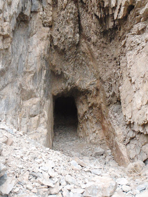
Properly fueled, we hit the dirt roads again. North of Chidalgo Canyon we discovered numerous mines. Some of the sites were just remnants, others were simply a caved in hole in the side of a hill. However, we did find several mines that had been a going concern in their day. The "Casa Diablo" mine had huge mounds of talings, several foundations for cabins, a small mountain of trash (old tins, cans, glass, etc...) and , of course, a deep mine shaft. I went into the shaft cautiously and quietly and my headlamp became neccessary after about 20ft. There were a couple of small cave-ins that had been shored up with boards and logs. I studdied them with care before continuing. I started getting creeped out after about a hundred feet. My light couldn't reach the end of the tunnel and behind me the mine entrance was just a distant light. Enough. Time to get out.
We found another significant mine site, the "Slim Chance". Despite the claim's name there was every indication that this site had been in buisness for quite a while. The remains of two cabins, one still standing, were perched on the hill of a little canyon. The mine shaft had significant cave-in damage at the mouth though one could peer into the shaft by shoving aside some rocks and dirt. As at Casa Diablo there was a big trash heap, talings piles, and other deritrus.
Returning to the roads we headed north through miles of desert, eventually arriving at the derelict Benton Hot Springs, a village of about 100 people whose sole economy was based on it's stagecoach stop heritage and what few people could be attracted to the spring. Continuing north and west we drove on black-top through a largely untouched wilderness of high valleys, mesas, and plateaus. Truly beautiful country with surprises around every corner. Soon we descended into the southern edge of Mono Lake.
Turning north on 395 we passed Lee Vining and hung a right on the road to Bodie State Historical Park. This site is a Gold Rush ghost town where the population exploded from 200 to 10,000 in the space of a year. Despite a fire in 1929 there remains at least 200 buildings in what the Park Service calls "arrested decay". A visitor can wander through the town, the residences, the church, and numerous businesses. One can see the mortuary, the assayer office, the school and several saloons. There are derelict cars, mining junk, old carriages, everything is still here. I'm at a loss to adequately describe this place. It's a touch of the old stuff, magical. I think the pictures can give you a better sense of it than 1,000 words of mine.We returned to Mammoth and spent the evening at Convict Lake under rainy skies. We'd had enough of rain so we had pizza and watched game 1 of the NBA Finals at the Restaurant at Convict Lake.


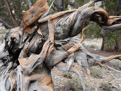
 We headed up into the White Mountains, finally arriving at Schulman Grove. This is the home of the Bristlecone Pine, oldest living organism on the planet (with the possible exception of a self-replicating creosote bush in Chihuahua, which by virtue of geography is certainly not the oldest living organism in America). These bristlecone pines are all twisted up in the most fantastic shapes, made that way by hundreds of years of dreadful weather. Very beautiful in a stark and lonely fashion. One doesn't see a forest in the common sense, more like rugged individuals clinging to their own little scrap of rocky turf. Despite the wind, and the snow that it brought, we spent nearly two hours tramping around and shooting pictures of the trees. I found this to be an eerie and solitary place, high, aloof. I think it is the kind of place that forces one to reflect.


 We continued higher into the clouds and blown snow, following a wild and empty road through endless, top-of-the-world terrain. The storm only added to the feeling that we were rolling through a remote, seldom visited corner of the world. I know that plenty of people go up there but it just didn't feel that way, not on that day. We pulled out a couple of other times to shoot pics at another stand of bristlecones and eventually wound up at the White Mountain trailhead. It was damn cold there at 11,000 feet, windy and cold. Story of our week. I sympathized with anyone who was further up the mountain.


 Headed down we came across a road that said "Bishop 15 miles". Huh? We were at least 40 miles from Bishop unless one could fly, or so I thought. Time to consult the map, the GPS, the oracle, the chicken guts. Three different signs assured us that without 4wheel drive we would suffer a slow, agonizing death...well. Of course we have 4wheel drive! Say no more! Off we go! Silver Canyon Road was the name, and fun it was. Down, down, down we went on the narrow track. A fun but not too serious off-road adventure. It wasn't "real" 4wheel crawling, but it was entertaining, and as drives go, not for those afraid of heights, nor was it for those city people in their shiny Land Rovers who never learned to operate their low gears. But it was fun, and being as steep as it was, we got to the canyon floor quickly. On the floor we encountered a couple of abandoned mines, one of which was a real claim at some point. The other was just a test dig, probably abandoned when it failed to show any color.


 Chidalgo Canyon is something special. I'll go out of my way for pictographs or cave paintings but this road boasts three large, significant pictograph sites right off the raod, all of which seem to have been respected by the local beer-swilling teenagers. We saw hundreds, perhaps thousands of pictographs in a couple of hours. Some were pretty easy to identify: elk, baskets, medicine wheels, snakes, water, etc...Others were beyond my ken. My favorite appears to be a five year old's rendition of a robotic space alien taking siesta.


 Eventually we left for Red Rock Canyon (how many of those are there on earth?). Despite the unoriginal name (which in this case was entirely appropriate), we were amused to discover a single lane track winding through red bluffs that crowded the truck. It was so fun, in fact, that we drove through it 3 times at increasing speeds. Rivas got a good video of us shooting the gap. A novelty,perhaps, but fun.
 We wound up at Tom's Place on the 395 by crossing the dam (damn dams) at Lake Crowley. We found a place to camp up on Rock Creek. Cold. Brrr cold! Windy. Raining in fits. Like the rest of our week. We set up camp and Dave pulled out the dutch oven. The Entree du Jour was chili with corn bread topping. Succulent. We'd had a long day, all of it good.


 Honestly, we had put up a good effort, kept our heads, and displayed a stubborn resilience. Now it was time to accept the realities and demonstrate another attribute of all smart mountaineers...good judgement. Each day the weather had started earlier, lasted longer, and became more intense. It was time to go down.
 We threw our kit together, shot a last picture (until next time) of Middle Pal and started descending. We were both a bit morose, though Rivas descibed it as "melancholy". I think I was a bit more prosaic about things; that's just the way it goes sometimes. We had all the experience and equipment needed to ascend the mountain, even in these conditions, but the weather had the final veto. Had we ascended we would undoubtedly have wished we hadn't. And that's called mountaineering. You only win if it's a round trip.
 So yeah, I was a bit frustrated and disappointed as we reversed our route, but at the same time I was already thinking of other things to do in the Owen's Valley. To my way of thinking, being shut out of your primary goal provides an opportunity to experience something else. Now, I know a good deal about the Owen's and it's holdings but I also know there's alot left to see, so that's what I was chewing on while trudging down the snow and rock on my way to lower elevation. As a parting shot, the rain started around 10:30, complimented by an icy breeze at our backsides to usher us out of the mountains.
 Back on asphalt, we headed down to Bishop, devoured a pizza and headed out to the Keohe Hot Springs. The locals call the place "the ditch", and I suppose they're entitled to be a bit elitist about their hot springs, given that there are many in the Owen's, but I like the place. What the Keohes lack in ambiance, they make up for in ease of accessability. Naturally, the rain and wind had followed us out of the mountains. It was pretty nice to be warm for a change, and a hot soak felt even nicer with the gentle patter of rain on my dome. We eventually spent the night at Tonopah campground, a place that has little to recommend it in the light of day, however, the picnic tables aren't warped and are therefore comfortable to sleep on. Before turning in for the night, Dave and I created a short list of place to see and things to do. Thus began the second half the week. This final shot is of the Keohe springs. Road-Trip diary begins tomorrow.


