 After a blissfully precipitation free night in the Tonopah Dustbowl County Campground of Inconsequence we got coffee and gas in Big Pine and headed east. There is an array of radio telescopes outside Big Pine that have always caught my attention so this was the first stop. They're big, and white, and they emit a low frequency humming noise, yet I couldn't understand what they were saying to our friends "out there". Maddening. Like answering a question with a query.
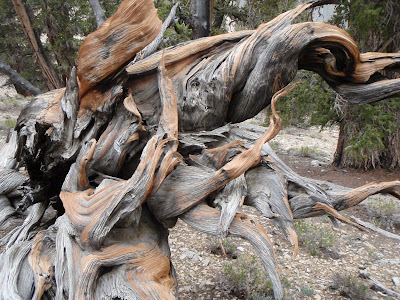
 We headed up into the White Mountains, finally arriving at Schulman Grove. This is the home of the Bristlecone Pine, oldest living organism on the planet (with the possible exception of a self-replicating creosote bush in Chihuahua, which by virtue of geography is certainly not the oldest living organism in America). These bristlecone pines are all twisted up in the most fantastic shapes, made that way by hundreds of years of dreadful weather. Very beautiful in a stark and lonely fashion. One doesn't see a forest in the common sense, more like rugged individuals clinging to their own little scrap of rocky turf. Despite the wind, and the snow that it brought, we spent nearly two hours tramping around and shooting pictures of the trees. I found this to be an eerie and solitary place, high, aloof. I think it is the kind of place that forces one to reflect.


 We continued higher into the clouds and blown snow, following a wild and empty road through endless, top-of-the-world terrain. The storm only added to the feeling that we were rolling through a remote, seldom visited corner of the world. I know that plenty of people go up there but it just didn't feel that way, not on that day. We pulled out a couple of other times to shoot pics at another stand of bristlecones and eventually wound up at the White Mountain trailhead. It was damn cold there at 11,000 feet, windy and cold. Story of our week. I sympathized with anyone who was further up the mountain.


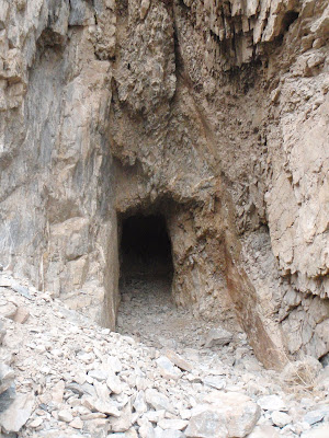
 Headed down we came across a road that said "Bishop 15 miles". Huh? We were at least 40 miles from Bishop unless one could fly, or so I thought. Time to consult the map, the GPS, the oracle, the chicken guts. Three different signs assured us that without 4wheel drive we would suffer a slow, agonizing death...well. Of course we have 4wheel drive! Say no more! Off we go! Silver Canyon Road was the name, and fun it was. Down, down, down we went on the narrow track. A fun but not too serious off-road adventure. It wasn't "real" 4wheel crawling, but it was entertaining, and as drives go, not for those afraid of heights, nor was it for those city people in their shiny Land Rovers who never learned to operate their low gears. But it was fun, and being as steep as it was, we got to the canyon floor quickly. On the floor we encountered a couple of abandoned mines, one of which was a real claim at some point. The other was just a test dig, probably abandoned when it failed to show any color.


After refueling in Bishop we headed out to an area called the Fish Slough. I'm not sure what the name is about but I do know that this mineral-rich watershed is a protected fish hatchery type place. We found an seemingly endless, straight-as-a-ruler dirt track that headed out to an area called Chidalgo Canyon. Dirt roads are fun at 80mph, like hydroplaning except you can have your windows down because it's not raining. Oh yeah, it was raining.
 Chidalgo Canyon is something special. I'll go out of my way for pictographs or cave paintings but this road boasts three large, significant pictograph sites right off the raod, all of which seem to have been respected by the local beer-swilling teenagers. We saw hundreds, perhaps thousands of pictographs in a couple of hours. Some were pretty easy to identify: elk, baskets, medicine wheels, snakes, water, etc...Others were beyond my ken. My favorite appears to be a five year old's rendition of a robotic space alien taking siesta.


Chidalgo Canyon is something special. I'll go out of my way for pictographs or cave paintings but this road boasts three large, significant pictograph sites right off the raod, all of which seem to have been respected by the local beer-swilling teenagers. We saw hundreds, perhaps thousands of pictographs in a couple of hours. Some were pretty easy to identify: elk, baskets, medicine wheels, snakes, water, etc...Others were beyond my ken. My favorite appears to be a five year old's rendition of a robotic space alien taking siesta. Of particular note is a Kokopelli figure. Kokopelli is traditionally associated with the Anasazi and, to my knowledge, is only found in the Four corners southwest. But here he was. The features are a bit different than on a traditional Kokopelli but there can be no doubt about what the artist was attempting to create. We hear about these trade routes between ancient peoples and evidence supports the idea. Owen's Valley obsidion has been identified as far east as the Cherokee Nation. My theory is that there was a cross-cultural exchange of more than just material goods. I know I can't be the only person to recognize the Kokopelli for what he is. I've gotta do some research on this.

 Eventually we left for Red Rock Canyon (how many of those are there on earth?). Despite the unoriginal name (which in this case was entirely appropriate), we were amused to discover a single lane track winding through red bluffs that crowded the truck. It was so fun, in fact, that we drove through it 3 times at increasing speeds. Rivas got a good video of us shooting the gap. A novelty,perhaps, but fun.
 We wound up at Tom's Place on the 395 by crossing the dam (damn dams) at Lake Crowley. We found a place to camp up on Rock Creek. Cold. Brrr cold! Windy. Raining in fits. Like the rest of our week. We set up camp and Dave pulled out the dutch oven. The Entree du Jour was chili with corn bread topping. Succulent. We'd had a long day, all of it good.

Eventually we left for Red Rock Canyon (how many of those are there on earth?). Despite the unoriginal name (which in this case was entirely appropriate), we were amused to discover a single lane track winding through red bluffs that crowded the truck. It was so fun, in fact, that we drove through it 3 times at increasing speeds. Rivas got a good video of us shooting the gap. A novelty,perhaps, but fun.We wound up at Tom's Place on the 395 by crossing the dam (damn dams) at Lake Crowley. We found a place to camp up on Rock Creek. Cold. Brrr cold! Windy. Raining in fits. Like the rest of our week. We set up camp and Dave pulled out the dutch oven. The Entree du Jour was chili with corn bread topping. Succulent. We'd had a long day, all of it good.


Crap non summit days made for some good alternative days. As for the abundance of pictographs, are they all legit?.
ReplyDelete