***Okay, before anybody else reads this and tells me: a.) that I didn't get to the actual Fishbowls, and b.) that I was mistaken about there being a fire tower on Alamo Mtn, let me get a chance to get my act together. In regards to the Fishbowls, I very much failed to get to the actual pools, a lapse I will correct shortly. I admit that I did zero research for this hike, no internet, no consultation with someone who's been through there, and didn't look at a map other than to calculate milage. Duh. As for the Fire Tower which I said can be found on Alamo Mtn, let's revise that to Frazier Mountain (thank you Red). I used to ride a dirt bike all over those hills but it's been a while since I went through there, got my peaks mixed up, easy to do from the back of a motorcycle at 60mph. So yeah, I am guilty of not only single-minded hubris (concentrating primarily on miles and speed) but misinformation (about Alamo/Frazier), which is not a happy place for me to be. I'll correct the post and revisit this area after consulting a map. How's that for an idea? Get your shit right, Davo. Sorry about this, and thanks for the correction. I take this sort of thing, getting my facts wrong, pretty seriously so I'm a wee ticked at myself. I will endeavor to do better in the future.
Faithful friends, I apologize for the lack of recent material. Rest assured, I have some good stuff in the pipe, but for today I do have this little 22 miler to share. Mostly I've spent recent weeks cranking up my cardio at the gym, tightening other parts of me in preparation for this thing Davi Rivas and I do every June, and I've been spending a lot of quality time with my lovely wife Ruth.
So, how's this sound? Twenty-two miles of backcountry in nine hours flat. Just a quick little walk with a new friend to the blog, Chris Ferrier. Chris is fresh off a 50 mile trail race which he was able to complete in 12 hours and change. I hike fast, and when paired with somebody I am usually out front. Not today. Not with Chris. The sonofagun is 6 feet 6 inches tall! Being 6ft tall myself, I can appreciate how much difference a longer stride can make. I now know how Ruth feels when we hit the trail, and I can better understand why she always seems to be running to keep up with me.
I wasn't struggling to keep up with him, but I don't like having people on my ass so I just let Chris take point. In fact, I pretty well out-paced him on the steeps. There's not many people I know of who can catch me on the long hills yet ( I turn 40 in a few weeks, which, as everyone knows, begins the long downhill slide to arthritic, senile oblivion).
We start this post with a short, but steep hike to an old fire lookout called Thorn Point (I freely admit that I knew nothing about any lookout tower on the Point. It was just a trail and a high spot on the map to me, so this ended up being like, a bonus discovery, which I have now denied you because you just read about it). Both of the routes in today's post start from trailheads off Grade Valley Rd above Lockwood Valley. Thorn Point is a fun hike that climbs 2,000 feet in 3.6 miles. Steep. Chris and I paced it out in 70 minutes.
This route is a pleasant, well established and well traveled trail. The trail was designed for horses and was crafted back when people knew how to create a trail that lasts. This area, Grade Valley and Johnson Ridge, were not spared in the 2006 Day Fire, but the recovery has been impressive. We climbed through open, grassy, flowering spaces separated by stands of pine, cedar, and the occasional oak. Most of the trees have shed their charred lower limbs, and the upper portions are a riot of green. Large sandstone formations dot the higher reaches of this route, some of them ending on dramatic points with their own special views. A mountain lion had passed through over night, headed the way we were coming from. The cat had a 4-4.5" print, a fair sized cat, and we later encountered the same track and followed it through most of our second trail of the day, the Fishbowls Loop.
 |
| Thorn Point fire lookout. |
The lookout tower on Thorn Point was part of a system that was created in the 1930's. There used to be fire lookouts on Reyes Peak, Santa Paula Peak, Frazier Mountain and here at Thorn. Several other towers existed in the SLP but I haven't been to those sites. During WWII these towers played a dual role as observation posts for civil air defense. The Japanese had developed weather balloons that could carry a 100 pound bomb off the Pacific and when the balloons lost lift, the bomb would fall where gravity and the breeze took it. Several of these bombs successfully landed and detonated in southern California, though damages were negligible (these balloon bombs and a single torpedo to the Goleta Pier were the only physical attacks by the Japanese Navy on the US mainland). Sometime in the late '60's this site were upgraded with a raised steel structure upon which the lookout cabin was built.

Atop the Point, one can ascend the stairs and get inside this old tower. As expected, the place is a bit of a mess inside, but the furnishings and fixtures are remarkably intact. In one corner squats an old cast-iron stove of unknown age, while a few feet away is a Sears gas range that I'd say came from the 70's. Several cabinets and desks in the structure have a home-made feel, and these have been filigreed with hand carved images of squirrels, deer, and mountain lion. Among the scattered trash we were able to find incident report forms from 1962. The 360 degree views are impressive: Cobblestone and Alamo to the east, Lockwood Valley and Mt Pinos to the north, Reyes Ridge to the west, and to the south one is afforded views of the Sespe and the front range peaks such as Topa Topa, Santa Paula, Nordoff Peak, and Hines. This is a pretty cool place, one I'd like to revisit for a mellow overnight. Based on the hour we spent there, I think that spending an evening in the lookout would be a pretty cool thing.
 |
| Old wood burning stove. |
 |
| One of several carvings found on cabinet doors. |
 |
| Looking SSW from the north wall of the lookout. |
 |
| Looking ENE toward Cuyama. |
 |
| Chris, leaving Thorn Point. |

 |
| The upper reaches of Thorn Point are peppered with interesting formations. |
 |
| Chris, high above Grade Valley. |
 |
| Prints of the cat we followed for most of the day. |
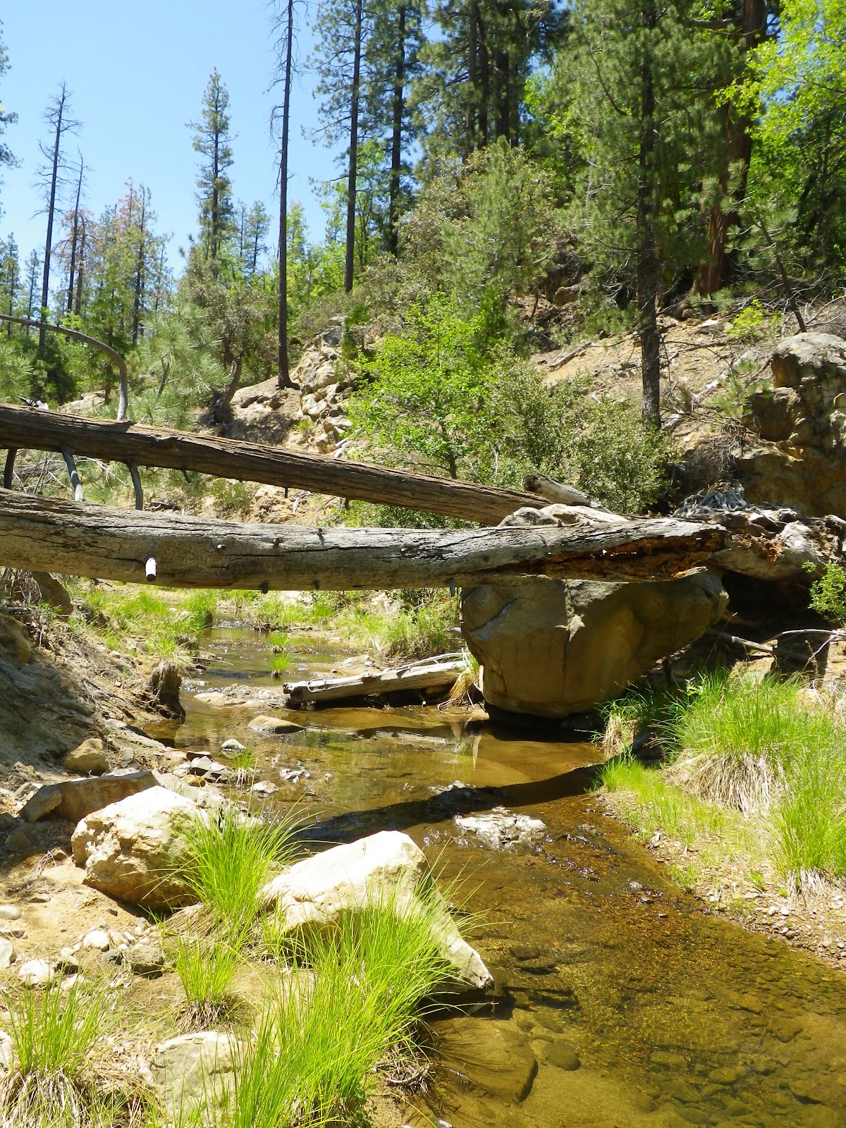
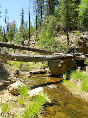
Having descended from Thorn Point, Chris and I relocated several miles to the Fishbowls trailhead, a route neither Chris nor I had done. This is a relatively flat, well defined trail which transits through a small valley through which runs the headwaters of Piru Creek. This route's early miles pass through stands of scorched pine and flowering meadows alive with birds. The day could not have been more perfect, blue-bird skies, temps in the low 80's, with a steady breeze. This open, rolling high country was super friendly and we averaged well over 3 miles per hour, though Chris's ridiculous stride kept him out front. We crossed Piru Creek several times on this journey to Fishbowls Camp, the creek being wide and shallow, water levels below par. We did spy many brook trout, the biggest being about 7-8 inches.
 |
| More matchstick forest. Seems to be a theme lately. |
 |
| The Fishbowls Trail. |
 |
| Upper Piru Creek. |
After roughly seven miles of high and piney country one reaches Fishbowls Camp, which isn't a place I'd say was accurately named. I think that with a name like "Fishbowls" I very reasonably assumed that there'd be some deep, cool swimming holes in the neighborhood. Nope (Wrong! Wrong! I plain ole missed it!). Piru Creek is a shallow trickle of ground water this high up so we settled for a bird bath, a good dunking of the head. The campsite itself is pretty nice, creekside with several large boulders crowded under tall cedars. A nice little place, until the bugs arrived. By the time I'd swept aside my fourth mosquito it was time to go.
A short time after leaving Fishbowls we encountered the only significant grade this route has to offer. This hill climbs about 800 feet to a saddle before beginning the descent into the adjacent, and appropriately named Cedar Canyon. Personally, I enjoyed Cedar Canyon more than I liked the Fishbowls trail. First off, most of the canyon escaped the Day Fire so the trees and undergrowth are more mature, the route shadier with much more of what makes these old forests enchanting. This canyon is home to some incredibly old and magnificent cedars. Cedar Creek is cold and crystal as opposed to the ground water trickling down the headwaters of the Piru. The birds and squirrels of this canyon seem even happier than their cousins one valley over, chirping, cheeping, and calling as we passed through their domain. I really enjoyed this stretch of our day.

 |
| Chris at the high point separating Fishbowls Canyon from Cedar Canyon. |
We paused on Cedar Creek for a pleasant lunch before moving downstream toward Grade Valley. These miles are shady and scenic. Chris resumed his position out front and we blazed our way through. As we approached Grade Valley Road the trees thinned and we were back in the afternoon sunlight. On the road we turned north for a circuitous mile before the truck came back into view.
 |
| Primordial fungus gnawing away at a fallen giant. |
 |
| I can't tell if this old cedar was machine gunned by woodpeckers before or after it came down, Probably both. |
 |
| Chris staring up at a 150 feet of old growth cedar. |
 |
| Cedar Creek nearing Grade Valley Road. |
This was a great first outing with Chris. He came as advertised, full of juice for the long miles. We got along well and I look forward to teaming for future endeavors. As for both Thorn Point and the Fishbowls Loop, both routes are thoroughly enjoyable and make a good pairing for an extended trail day. The views from Thorn are well worth the walk, and the fire tower is a treat. The Fishbowls trail is an easy route through beautiful forests and pleasant meadows, again, well worth your time. And I look forward to going back and visiting the actual fishbowls of Fishbowls Canyon.