Thursday, August 30, 2012

Sespe Connect, Stage II. 08/27/12

Part deux, the second stage of our descent of the Sespe River. Back in the drink with Jack Elliott for a second dose of whatever the Sespe had to offer. This portion of our Sespe Connect project takes off from Tule Creek where we'd ended Stage I (Cherry Creek to Tule Creek), and travels roughly 10 miles to the Piedra Blanca trailhead. I can't speak for Jack but I figured we were in for another day of brush, cattails, murky ponds and bone dry creek bed. Stage II had plenty of each, but much more besides. This was a sweet stretch of relatively untouched native aquatica. Stage II turned out to be a surprisingly fun and interesting walk.

Stage II in blue. A portion of Stage I in yellow. 
The Sespe at Tule Creek in the morning light.
As we did during Stage I, we opted to take the creek the whole way to our destination even though there was an option to get out of the creek and take the Middle Sespe trail. Neither Jack nor I had any interest in walking a hot and brushy trail when given the chance to wade downstream through Cottonwood Lane. We dropped into the creek and immediately began rock-hopping into the rising sun.    Within minutes we were in the drink, sloshing down a wide and shallow stream shaded by willows and maple. As we neared the Feser Cold Springs ranch site the creek abruptly went underground, leaving us only a dry and rocky creek bed fenced by drying, dying cattails. 

The phenomena of the "vanishing creek" is fairly common throughout our region during the dry season. Below a sun bleached creek bottom the ground water remains, drawn downhill and reconstituted later as a shady avenue of tree lined pools. This was the case for most of this stage, arid and treeless rock garden ceding to a lush water world. I'd say that the day was 50% one or the other, but unlike on many portions of Stage I, we encountered less of the marshy and mucky in-between stuff. It was served up neat, wet or dry, bartender's preference.


The glare on a wake of pond film.
All the plants out there look dried up, just not the ones that live on the creek.


Shady lanes of cottonwood.

We snuck past the Feser site, which is mostly a barn and a double-wide on a shelf above the creek, and entered what is known as Middle Sespe. More time in the water walking the twists and turns of the creek. More foot-dragging through ankle deep sand, hopping rocks and dodging yucca. But for all that, it was surprisingly pretty and Jack and I both remarked that this place felt pretty native, un-messed with. This stage started from Hwy 33, but that road climbs up and away from the Sespe and the further into our morning we got, the more remote our surroundings felt. Which was perfectly okay with us. The going today was surprisingly easy (much less brush than on Stage I) and by mid-morning we had blown past what used to be Beaver Camp. Somewhere in that sunny and perfect day I came to the conclusion that I was really having fun. It just turned into that kind of day. We'd pull out of the creek and scramble up a stack of boulders just to see the view, or stop to investigate something that caught our eye. It was a very low stress day, and as I say, fun.

Rock formation, Middle Sespe.


A bone dry section of the creek. The trees know where this creek goes seasonally dry. Far fewer trees through the drought sections.
Jack, somewhere in Middle Sespe.


A sluggish, filmy section of Middle Sespe.  Looks like bayou.

As with our experience on Stage I, we had some interesting wildlife encounters on this portion of the Sespe. First of all, I got to see a Red-breasted Merganser Mergus serrator. As the name implies, this colorful duck does have a robins red chest. It has a flare of white on the wing tips, a white collar at the throat, and beautiful almost iridescent dark blue back feathers. A very pretty duck, and rare I think, in Southern California (I could easily be wrong on that).  Somewhere through Middle Sespe we had a pair of giant bullfrog encounters. Neither of the 6-7inch long, 5 inch wide monsters were especially impressed with our presence. I spotted a heron, a huge red tail hawk, several pair of mallards, numerous small birds. We often were accompanied by one or two butterflies of various species. They seemed to stick with us for a ways and then hand us off to the next guy in line, sort of like state troopers escorting a troublesome out-of-stater straight down to the border (been there, didn't get a teeshirt). Let's see, oh yeah! A gorgeous and fully grown doe lept into the creek just 30 feet ahead of us and stopped there, looking at us for a second before bounding across the creek and into the trees where it vanished. That was cool. I dig that. Didn't see one snake today. I thought that was kind of weird but whatever.

Super Bullfrog #1!


Super Bullfrog #2! You can use the willow leaves that he's so artfully arranged to get an idea how big this dude is.

Super Bullfrog #2! Close-UP!


I was immediately reminded of some battle-ground water hole in the Serengeti. Check out all the tracks, not one of them human.


The rest of the day remained fun and interesting, and pretty easy travelling. The route was consistently pretty but few parts of this section of the creek really stand out in my memory. This was one of those "It's the journey..." days. We found ourselves pretty much done by noon and out to Jack's truck by 13:00. Easy Peezy. 

Now, as for stage III, I think we will end up using the Sespe River Trail. That stretch, from Piedra Blanca to about Goodenough Rd at Fillmore, will be taxing enough without adding 17 miles of creek bottom to the route. It will take some scheduling but that is already sort of in the works.

Jack in the drink.
This formation can be seen from the flat below the Piedra Blanca trailhead.


Friday, August 24, 2012

Poison Oak, the asshole of the plant world.

Hate. Despise. Loath. Detest. Abhor.
Find me a better verb because these aren't doing it. 
{*With apologies for editorial license, this post gets helpful on paragraph 3}

This plant pisses me off, offends me. It's existence is all the proof I need that there is no God. 
The Old Testament God Yahweh was too self-obsessed to be inventive enough to plague mankind with as insipid a plant as poison oak. The New Testament God hasn't shown much interest in the human condition and is probably sending our prayers straight to the big-answering-machine-in-the-sky while vacationing with Aphrodite on the lotus flower reef world of Quonk-6 for the next millennia.
  

Buddha says all life is suffering, which certainly applies to poison oak. Buddha is usually right about these things. I frequently wonder what Darwin's explanation for how we ended up with a plant like poison oak would be.  Life finds a way. Life always finds a way to fill a niche. And Life doesn't care if you get a rash. It just doesn't give a shit.

Now that I've stepped on somebody's belief system, lets talk turkey. Poison Oak is a fact of life in our Southern Los Padres (SLP). It inhabits the drainages of our local mountains, sprinkled through the creek beds in a seemingly random way (ever wondered why you see so much poison oak nearer to campgrounds and popular creek areas, but not nearly as much out on the trail?). I have a theory involving coyotes and the god Ah-Puch (Boss of Mintal, or Level 9 of the Mayan underworld.)  In a region full of unpleasant plants, poison oak is the worst (to me). I'd rather get scratched six ways to Sunday than get near the stuff. You may infer from this that I've gone a few rounds with "the oak" and you'd be right. Injected steroids. Oral steroids. Prednisone psychosis syndrome. Benzodiazepines and prescription grade histamine blockers. Antibiotics. Been there probably a couple dozen times. I liken a bad poison oak exposure to an acute case of leprosy garnished with shingles.

The medical term for such an exposure goes like this: 
Contact Dermatitis secondary to Poison Oak Exposure
The patient is, at the least, experiencing a moderate rash at the exposure site. My type of reaction to a big dose of the oak is pretty bad news. I don't suffer from full anaphylaxis, but it's close. Of course I get the rash and bubbly eruptions which weep and can lead to cellulitis (skin infection), but the spread and scope of the reaction surpass what would be considered even a bad case. I get it bad. 

Somewhere out there somebody has a complete list of every suggested remedy for poison oak. There are a million suggestions, it seems. "Try Formula 409! The chemical burn will make it better!". Sure. Oatmeal compresses. Calamine Lotion. Benadryl Gel. Hot showers. Cold showers. Rubbing alcohol. Sunlight. Ice packs to freeze the epidermis (self-inflicted frost bite). Bath Gin. Vinegar. Mugwart. BBQ lighter fluid. Eye of newt. Toe of frog. I've tried 'em all. Here's what seems to work:
  • Be immune, or at least un-caucasian
  • never go outside your comfortably consumerized urban life zone
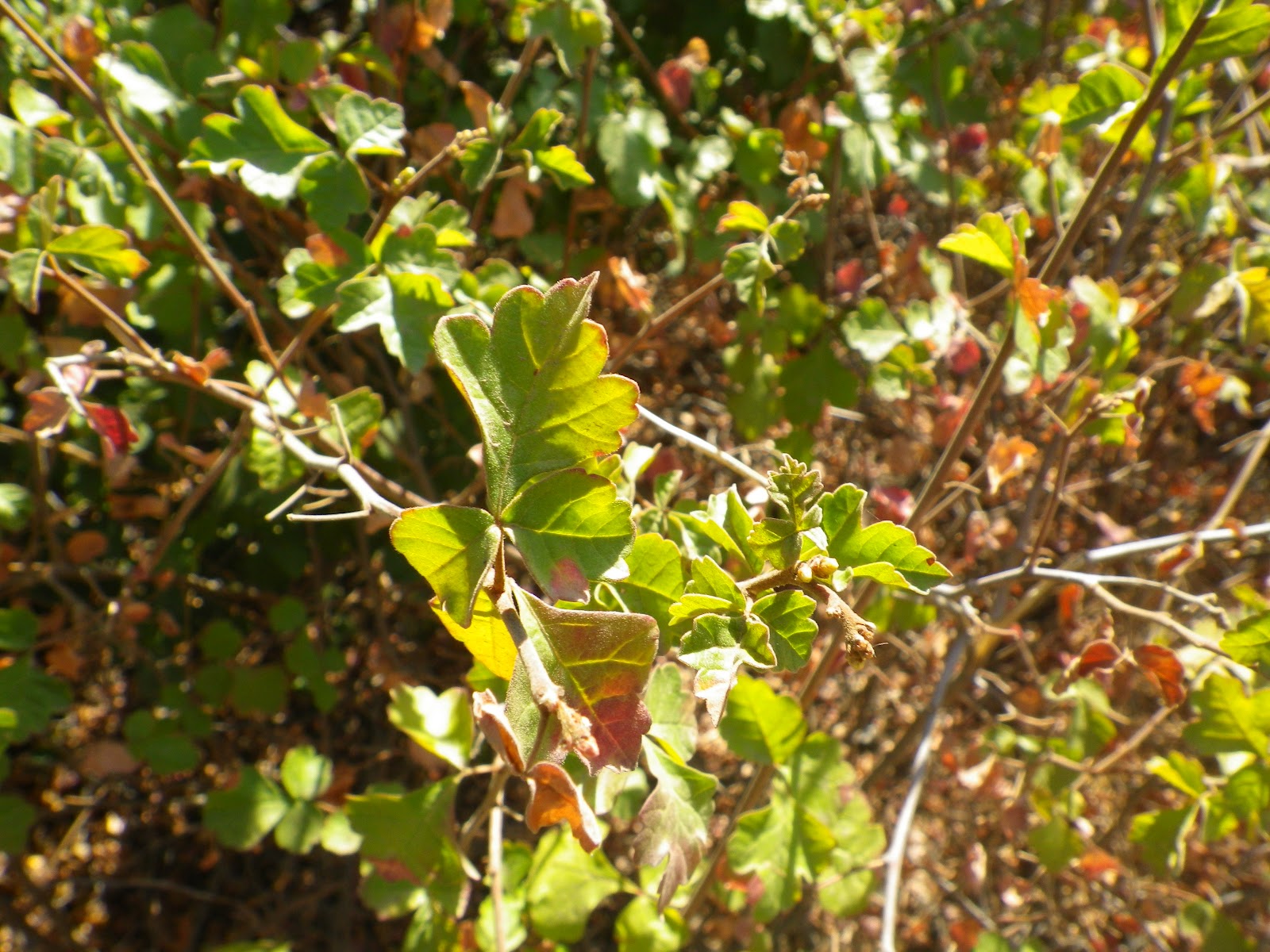
  • Know thy enemy. Become adept at recognizing poison oak. This plant is deciduous and will undergo changes from large broad leaf green to red and eventually just the vines will be exposed. The vines, in my opinion, are the worst, as they leave long scratches and resultant stripes of the stuff on exposed skin. 
  • If exposed, you have 15 minutes to get it off you before the damage is done...
  • ...Unless you use a marvelous product called Tecnu (available at most major drug store chains). Follow the directions. Scrub aggressively with this anti-oil soap within the first hour of exposure. This stuff works exceedingly well if used as directed and somehow it also helps clear already exposed areas. I have had a solid exposure greatly reduced in time and discomfort by continuing use well after exposure. I always have a small bottle of Tecnu in my pack. I use it instead of detergent to wash exposed clothing and gear. Also, I keep a spray bottle of Tecnu diluted in a bit of water in my truck. This is a good applicator for large areas or generalized exposures. This is a miracle product. Lacking Tecnu in the instance of a known exposure on the trail, try rubbing finely crushed dirt into the exposure, let the dirt stay on the skin for a while and then rinse it off. The dirt may absorb some of the poison oak oils and limit the degree of the exposure.
  • Steroids (Prednisone, Decadron, Solu-Medrol) the sooner the better. Steroids are unpleasant to take, but they are often the only thing that treat patients with a severe allergy to poison oak. Steroids have serious side effects and should be taken as infrequently as possible, and only as directed by a physician.
  • Antihistamines (Benadryl, Zyrtec, Hydroxyzine, Pepcid, Zantac) to block the itch (kind of)
  • Benzodiazepines (Valium, Ativan, Xanax) so you don't freak out, and for sleep... if that's your thing and you can persuade your doctor to prescribe it. 
  • Calamine, the trick is to apply multiple layers to the rash over the course of the day. "Paint" the exposure repeatedly until the calamine becomes a thick, absorbent layer of pink chalk. Contrary to popular belief (and marketing), I have not found Calamine to have any significant benefit in terms of the itch, it does however dry out the lesion which shortens the overall course of exposure. The active ingredient in Calamine has been added to some messy, gooey products such as Benadryl Gel. Gel products are not a good idea for a fully developed and weepy rash. They tend to trap surface bacteria which can increase the likelihood of developing cellulitis. 
  • Luke-cold showers with Ivory or castille soap, pat dry. Scalding hot water showers may feel amazing on a developed rash, orgasmic even; that is because your nervous system is being drenched in histamines. That scalding hot water may feel good on the rash, but it spreads the histamine response and with it, the itch. You can also cause serious tissue harm with the hot, hot water, setting yourself up for a skin infection when the rash leaks. 
  • Loose, cooling clothing such as hospital scrubs. A dry, cool environment helps.
  • Back in the bad old days when I drank I augmented this routine with a weeks' worth of alcohol and Vicodin. It helps, I can't deny it, but as a clean and sober individual I cannot condone staying intoxicated for a week.
  • Contrary to popular belief, you can't get poison oak from a person once they have thoroughly and completely washed the contact off. So you can't get it from somebody else's rash. Which is good because that would be gross.
Here's what doesn't work:
  • Soaps that say they are good a treating poison oak exposures. They all suck and are a waste of money. Don't be a sucker.
  • Supposed solvents such as household cleaners, mineral spirits, acetone, oven cleaner, etc... The potential for self-harm with these products far exceeds their potential benefit.
  • Poultices, magic, crystals, and prayer.
So go back up and look at the classical image of poison oak as painted in a "know your backyard plants" book. It shows a brown stem and three big, broad leaves with distinctively bumpy leaf edges. If  poison oak always looked like that it would be a lot easier to avoid, but that wouldn't be any fun then, would it? Right. Didn't think so. Read on friend, it gets worse. 


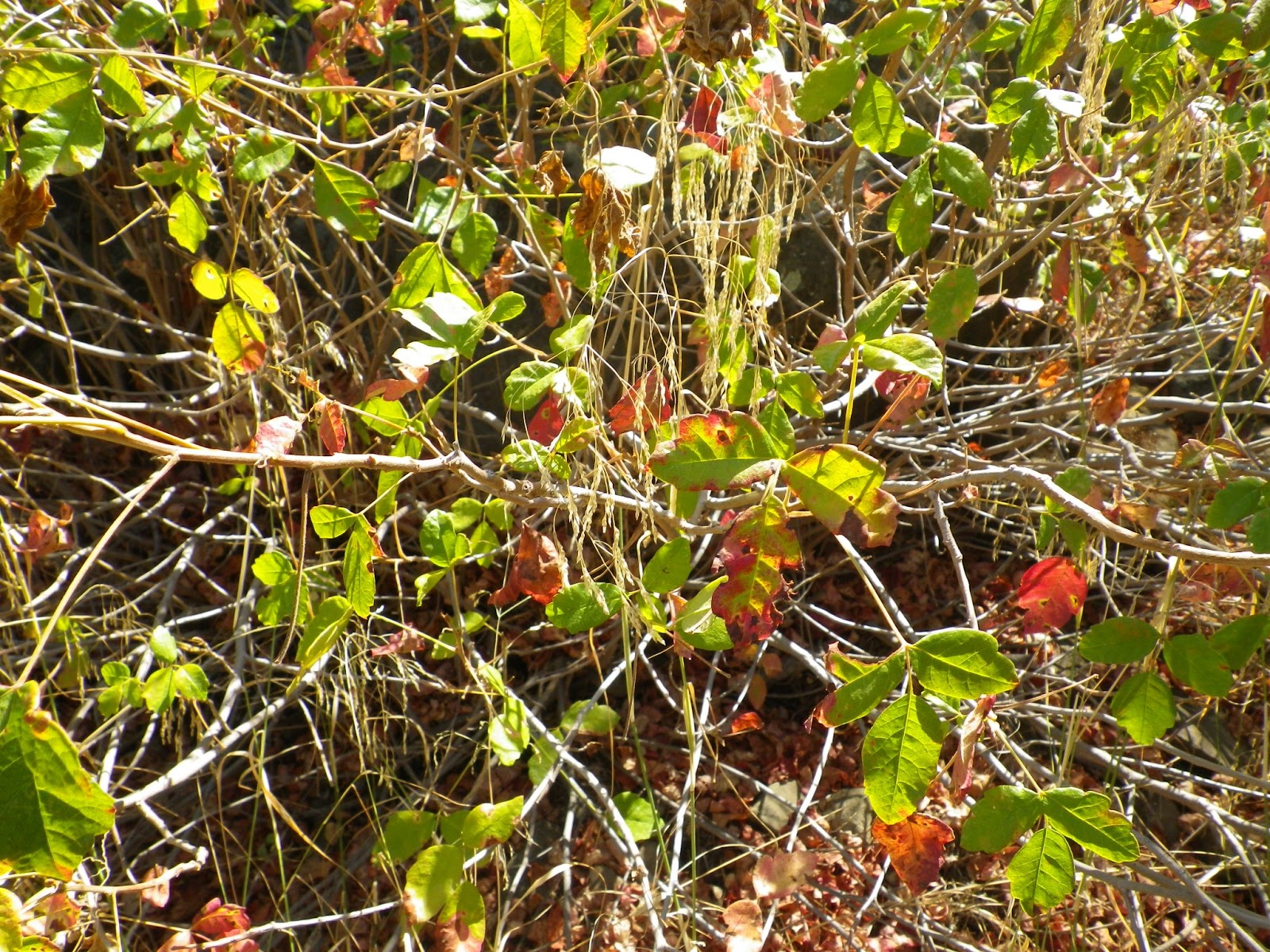
Developing a NORAD quality radar for poison oak takes the sting of experience, and it takes a good set of eyes because the stuff looks different wherever you turn. That's what I really wanted to talk about when I started writing this, the multiple morphologies of poison oak. In spring the leaves are small, clubbed, and venomously oily. In shady conditions these leaves grow rapidly into a kelly-green, broad leafed plant. These plants in the photo above grew exclusively in full sun and I've noticed that in those conditions the oak tends to stay lower to the ground, have smaller and glossier leaves, and are more venomous than their shaded neighbor. They also lose their leaves more quickly in the fall than poison oak which grows in a shadier environment. The vines, in particular, tend to "sweat" more oil in the full heat of day and, as mentioned earlier, leave nasty stripes on the skin that can be very painful when developed. Whatever you do, do not use poison oak as firewood because inhaling the smoke can lead to hospitalization and, in very bad cases, respiratory failure.

In pictures above you can see that the leaves of poison oak are broader, larger, more full and rounded. They clearly look different than the ones growing in full sunlight. These plants grew in partial to mostly shade. The shaded oak tends to be more viney, creeping up the surrounding plants and hanging from tree branches. It commonly grows in shady places you need to duck through. At face level. It lurks on that shady ledge you just put your hand on. It reaches out from under that fallen tree you ate lunch on. It looks different and acts different from the oak that grows in the sun. Morphology. Multiple shapes. Not cool. Crafty.

Shaded poison oak rusting into an early autumn
As we start rolling into fall the poison oak will fade to a bright red. The leaves will die and fall leaving only the vines. This can be big trouble for people who don't have that poison oak radar. The vines are the worst. They can leave a stripe that spreads like a comets' tail. These "stripes" are often quite painful, not just itchy, but really painful and the skin damage from a real scratch can leave serious scars. If you get poison oak avoid these vines like a zombie with ebola. They're bad news.

In developing that "radar" pay attention in the coming months to the leaves under areas you know from experience to be wooded with poison oak. The fallen leaves of our subject fade from a bright brick red to a sandy beige. As they dry the leaves shrink and become papery, light and crunchy. It's never happened to me but, knowing what an evil plant this is, I wouldn't be surprised if you could get a case of the stuff from laying on long dead poison oak leaves.

Seasonal change in poison oak from green to red.


This poison oak had pretty successfully weaseled into this patch of chaparral, spreading it's vines higher towards more light and fresh meat. 
If you are kind-hearted and empathetic you might deduce that I'm currently amid a poison oak crisis. Fortunately that is not the case (thank you if you had been wondering). No, I just happened to have had a discussion some time ago with Nico about the evident differences in the look of poison oak from one canyon to the next. All these photos were taken on the same day up Matilija Canyon. I would be interested in your observations, feel free to share.

Beware the poison oak that has shed it's leaves. It be hard to espy.


Thursday, August 23, 2012

An easy day up Matilija way, 08/21/12


How about a few photos from a leisurely day up Matilija Canyon? Ruth and I spent the other day up that way doing a bit of walking, some swimming, etc... It was another hot one above Ojai but that should come as no surprise. The water levels are low but flowing and the canyon is showing the signs of a high traffic summer, which is about normal for this time of year but compounded by the dry spring we had.We had a nice day in the canyon and eventually made it as far as the West Falls (I'd just come off my on-call weekend and wasn't feeling particularly energetic). Enjoy the photos and video (below).


Leaves in spider webs.


Saturday, August 18, 2012

Sespe Connect (Stage I), 08/15/12

Stillman in the sticks. photo:Jack Elliott.
Alright, let's break a champagne bottle on the bow of my latest brainchild, the Sespe Connect. Sespe Creek is a 60 mile watershed that starts at Potrero Seco a couple miles above Cherry Creek on Highway 33 and ends at the Santa Clara River below the town of Fillmore. Most of this stretch is a protected National Waterway and the Sespe is one of the only un-dammed, un-diverted rivers in Southern California. This Sespe Connect project is about linking the thing end-to-end, literally. This idea stared with a self-inflicted guilt trip. I have driven up Hwy 33 hundreds of times and on many of these rides I wondered what all lay in the creek bed just off the road. I'd ruminated on this long enough that it just kind of became a given that I'd have to undertake a downstream exploration, if only to satisfy my curiosity. I had to decide how far up the creek I wanted to put in, and I figured I'd end it at the Black Wall at Sespe Gorge or even as far down at Tule Creek. This is where the Sespe Connect idea sprang from; if I was gonna start at Cherry Creek and walk all that stretch, why not make it legit and just walk the whole river? 

I'd need a partner for this and I thought of Jack Elliott (link) first. He seemed to think about it for a little bit longer than normal before agreeing. I explained that the Sespe Connect was a side project, something to put together over some time. He was down for it and so we embarked on Stage I, the 8.6 mile stretch from Cherry Creek to Tule Creek. 

Jack Elliott, David Stillman. Sespe Connect (Stage I).
Here's the Stage I map, route in yellow.
Jack and I took off from Cherry Creek at 0800 and it was already a hot one. We walked a bone-dry creek bed for at least a mile before saw any sign of water. We could have been walking down any of a dozen seasonal drainages. The wash was wide and sandy, littered with cobbles. We encountered some of the usual stuff one might expect: shotgun shells, inanimate objects shot to shit, the occasional beer can with a bullet hole in it. A mile or two from our start we began encountering small stretches of mossy and muddy ground water and we proceeded into the green heart of a watershed in the throes of a severe dry-year crisis.
Blazing Star, Mentzelia laevicaulis
Prickly Poppy, Argemone munita. Originally misidentified as Matilija Poppy.
This 80 foot shale slide is clearly visible from Hwy 33.


This uppermost part of the stream (now that there was water) was a wall of overhead cat-tails so thick that the path of least resistance was to act like water. We weaved through these thickets using the deepest part of the creek as our guide. The reeds were so thick that we often couldn't even see our feet. We were soon covered in a neon yellow-green pollon that exploded from the smaller cat-tails. All it took was for us to brush one of the plants and poof!, we'd be hit with a blast of fine yellow dust that stuck in your nose and mouth and made your clothes look like you been in a yellow flour-fight (below). We further accessorized our pollon makeover with a general sprinkling of sticks, leaves, seeds, and unidentified organic matter.

Getting dusted on Hi-Grade pollon.


As you can see from the pictures above, the creek becomes a real waterway about a mile above the old Chorro Pack Station (which also used to be a stage stop where riders could change out teams and get a bite). We now walked entirely in the creek under a canopy of sycamore, maple and cottonwood. We scattered schools of little trout and frequently saw larger ones; we later saw two trout that measured in the 1foot range, give or take. We sloshed down an arbored path, glad for the shade and glad for the water. 

The old Chorro Station.


Eventually the trees gave way to open flats through which the creek travelled and thus did we. The creek here was broad and shallow, but definitely flowing.  We waded downstream, enjoying all the butterflies, dragonflies, fish, turtles and other critters of our local aquatic environments. I was out front for a fair bit of this walk and happened to be looking at the right times to see a couple different herons, and later a squawking duck flew off just above our heads. At one point I was out in front of Jack by quite a ways, walking down a shady water-lane when I heard something big and heavy snap off to my right. Then I heard it again, followed by several loud brush crunchings. Oho! We were not alone! I couldn't see what was happening just behind the ever-present wall of creekside reeds. I can tell you that I don't believe that a deer made all that noise. And it sure wasn't a person, I can tell you that. I opted not to investigate further.


Pretty pond.
Tweekerville. One of two homestead leases on this section of Sespe Connect.


Bunch grass in the creek bed.

Eventually the creek went back underground. This went on for at least a mile. We were back out in the heat. We walked sandbars and rocky shoals, saw a million more reeds. After a while we started getting to a section of the creek that I recognized from a previous exploration. At that time I'd been wandering in search of undiscovered bouldering (without a lot of luck). A short time later we entered an area called the Snake Pits (mile 33 from Ojai). This little gorge used to have a pair of long, deep pools. It was a popular area and one could jump from the rocks, swim laps, do a little over-water bouldering or catch some harmful UV-rays. A recent Mountain Gear catalogue had a picture of a guy slack-lining over the Snake Pits at sunset. The place was a bone dry channel of sand and gravel. No more swimming until the next big gully washer.

Fossils.

This fish had suffocated in a land-locked pool of stagnant water.

Dry creek bed.

More dry creek bed.


The Upper Snake Pits. Just a couple years ago this pool was deep and clear. You could jump from the rocks. 
The lower Snake Pits, bone dry and filled in with sand.

A mile or so below the Snake Pits we finally got to the junction of Potrero John Creek and shortly after that we saw the bridge at Derrydale Creek. Here we began encountering many of the larger rocks and boulders that had been missing upstream. I supposed that many of these boulders had washed down from the aforementioned creeks. We were back in the shade, sloshing merrily downstream when we passed under The Fortress and the Potrero John Wall: too hot for anybody to be out climbing today. We creek-slogged for another mile before reaching the Black Wall at Sespe Gorge, a place I know well. The water level gauge at the base of the wall read like a bad joke. We passed out of the early afternoon shade as we rounded the last big bend in before Tule Creek.

The bridge at Potrero John Creek.


Jack, Jack, Jack of the Jungle.

Jack and his silt wake.
The water gauge at Sespe Gorge (mile 31 form Ojai). I would guess that this is not good.
Sespe Gorge aka The Black Wall.


We found several warm sulfer seeps along the length of Stage I


For the whole story on this rarely seen snake-on-snake predation see: King Snake Kills!!!


We had two encounters with king snakes on this day, and one of the simply extraordinary. Jack and I got to witness a king snake straight up kill a garter snake and attempt to eat the larger garter (see link to story in caption above). Our second king snake was a long ebony and ivory beauty (think: piano keys).  I tried to pin him down but he was a quick and feisty adult, not having any of me. He slipped away easily, almost slithering over Jack's boots in his haste to get lost. I have mentioned before that king's are my favorite snakes and I felt doubly blessed by these experiences.

Jack and the King.


We continued toward the junction of the Sespe and Tule Creek, passing under a graffitied bridge and over to the east side of the 33. We climbed out of the creek and, in an effort to be thorough about this project, traversed under the rocky scarp that is high and left from the road when driving in the direction we were traveling. We didn't find much other than poison oak and cottonwood trees. We soon climbed out of the creek directly under where Jack had parked his rig.

So that's Stage 1 of Sespe Connect in a nut shell. I think we both had a fine day even if it wasn't the blood bath murder day we've both come to expect when out in the sticks together. And that's okay (once in a while). Stage 2 will be from Tule Creek to the Piedra Blanca Trail head, another brushy creekfest through Middle Sespe. And now I've also shared this idea with all of you, and if you feel like giving it a shot, knock yourself out. I only own the idea, the rest of this is teamwork and I've got a great off-road partner in Jack. We've both got other projects in the works (some joint) so stay checked in. We'll keep it coming. 

Sespe Creek at Tule Creek, and the end of our day.