Let me just start by saying that this was one of coolest places I've visited in the Southern Los Padres. The Piru Creek drainage, between Pyramid Lake and Lake Piru is, with the exception of a few miles at either end of the route, as remote and untraveled as any place I've been through. I will do my best to give this place the respect it deserves. Piru Creek is an incredible journey.
Nico and I put in below Pyramid Lake at a pullout called Frenchman's Flat above Castaic. A decent use trail takes off from the parking area and this route aims directly at the Piru Canyon. We set off with a rising sun at our backs and transitioned into the canyon quickly. These early miles are an easy walk and the path quickly joins Piru Creek, moving downstream through cottonwoods, willows, and easily avoidable poison oak. Several dirty and littered campsites dot this upper few miles of the creek, but after about an hour of walking we found that we'd descended into a rich, untrampled wilderness.
 |
| Nico, using our preferred method of travel. |
About the time Nico and I left the litter and unsanctioned fire pits of the first miles behind we were already happily sloshing through a narrowing canyon. By this time the use trails we'd been following had largely petered out, traveling through the creek itself was becoming more and more the most efficient way to travel. Remnants of trail can be found down this entire route, but we determined early on that any path off the creek has been commandeered for, and is maintained exclusively by bears. This was evident nearly every step of the day that we spent on the banks of Piru Creek. Bear sign, prints, and scat were literally everywhere along this creek ( I do not exaggerate ).

The creek itself is generally shallow and broad, though in high water years this route would be incredibly difficult on foot. We enjoyed sloshing downstream as the temperature rose. Occasionally we were forced up out of the creek by a deeper pool or sections of bionic plant growth. After 3-4 miles in, the creek starts weaving back and forth, doubling back on itself entirely in places. In wider portions of the canyon the creek has created brushy plateaus on one side of the creek or the other, depending on which way the creek has turned. At these big bends in the creek we'd climb out of the water and into these areas which were characterized by rocky sandbars and profusions of brush. Most of the time this approach would shave some distance, meaning we could over-land until the next bend in the creek, at which point we'd either resume travel in the creek or cross to the other side and repeat the process. Often the cue to cross the creek presented in the form of an impenetrable wall of reeds, or willow, or poison oak, but most often we were just able to sense that ahead was not the way and adjust accordingly.
 |
| One of a thousand brushy creek crossings. |
The floor of this spectacular canyon is seldom wider than 200 feet and seemed, for the majority of the route, to average about a hundred feet wide. The creek frequently hugs one side of the canyon's deep walls. At one such spot I'd just rounded a corner and had started crossing water for the hundredth time that morning when I heard something snap off to my right. I glanced toward the source of the noise and said exactly these two words, "Holy shit...". I was being observed from about sixty feet away by a big ole bear. We locked eyes for just a second before he turned into the brush. I struggled to get my camera into play as the bear faded into the brush ( that's the best I got, below). Nico was only a few feet behind me and was able to catch up in time to see the bear casually retreating into the brush. We quickly crossed to the other side of the creek and hurried downstream a ways before the alarm bells were quieted. That was a big bear. I know that every bear is big in person, but this old boy with his mangy butt stood 4-4.5 feet tall at the shoulder. Big. We were happy to put some space between the two of us.
 |
| A crappy, on-the-fly shot of our bear. |
A word about the brush situation...it's bad. This day of travel wasn't difficult in the classical sense, as in climbing a gnarly hill or pounding out massive miles. A good analogy might be to compare this to running up and down Matilija creek several times in a day. No two steps are alike. Step on a rock, step up to the next, down to the one after that, step sideways around a fallen branch, barrel through this plant, scramble over that boulder, and so on...and then there is the brush, which I'd describe as legendary. You have all the chaparral that we usually contend with on normal trails, but added to the mix are all the plants that dwell in the local creek bottoms, and these plants are healthy. Countless times Nico and I found ourselves thrashing through hundred foot sections of ridiculous, excessive growth. I was scratched and bleeding from a dozen cuts before noon. The combination of these two features, exuberant plant life and disorganized creek bed, made for consistently difficult travel. We stayed in the creek when possible, though that was frequently just as difficult given the mossy, unstable footing. We developed a kind of running joke in reference to the lack of any defined trail. When smack up against a towering wall of bullet-proof brush, and with no real indication of how to get through it, we'd resort to saying "Follow the bear!", which means that we'd resort to the Caterpillar D-9 bulldozer approach, a technique I refer to as the "brute-force ignorance method". I actually developed a technique that kind of worked in these situations, where I'd extend my arms out and coming together in a "V", trekking pole handles together as the point of this wedge, head down in the "V", apply full steam to the legs, and part the waters of this brush sea. Like I said, it kind of worked but really, nothing works as well in brush this dense as a good sense of humor.
 |
| The further we progressed into the canyon, the tighter it got. Nico working the brush. |
 |
| How pretty is this? Loved it. |
 |
| Nico eating brush, which builds strong bones and teeth. Part of any complete breakfast. |
 |
| California Condor. We had several sightings of condors and saw one pair in flight. |
 |
| Cobblestone Mountain from Piru Creek. |


This watershed is very healthy. I mentioned that this place is owned by the bears, but let me expand on the local wildlife that we encountered. Let's start with the birds we saw: at least 60 ducks (mallards and two other species I haven't been able to ID), red tail hawks, harris hawk, a woodpecker, the biggest great blue heron I've ever seen, hummingbirds, quail and dove, and multiple sightings of california condors (singly and one pair), and a big horned owl flew overhead as I closed my eyes for the night. Aside from the squirrels and the bear, the only other mammalian interaction came on Sunday morning as we were packing up. A skunk came into our creek-side bivy after an all-nighter and, completely nonchalant about the humans in his house, crawled into a den under a big boulder near by. We saw enormous alligator lizards, horned toads, a big garter snake, and two rare reptiles: a five foot patch-nosed snake (gorgeous snake), and a beautiful western skink with it's electric blue tail. I get the sense that this canyon might be a last hold-out for other rarities such as the ring-tail cat (quatl) which I have only seen once in our neighborhood (that was in Tar Creek many years ago). Nico indicated that he'd like to again come this way for the sole purpose of wildlife observation and I agreed, it's that kind of place.
 |
| Big bear print. Click any image to enlarge. |
 |
| Dead field mouse. |
 |
| Dead crayfish. |
 |
| I theorize that this beautiful CA King snake was killed by a bird. We hadn't run into people prints at that point, so I dont think this death was human related. I love king snakes so this was kinda sad. |
 |
| Patch-nosed Snake |
 |
| Long live the king. |
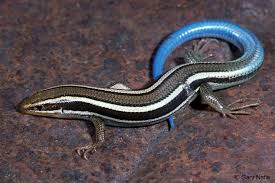 |
| Not my photo, but a very rare guy, a western skink. |
 |
| A rare patch-nosed snake, about 5 ft' long. Very fast. |

 |
| Large common garter snake. |
 |
| CA Condors |
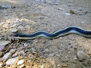 |
| A slightly better shot of the patch-nose. |

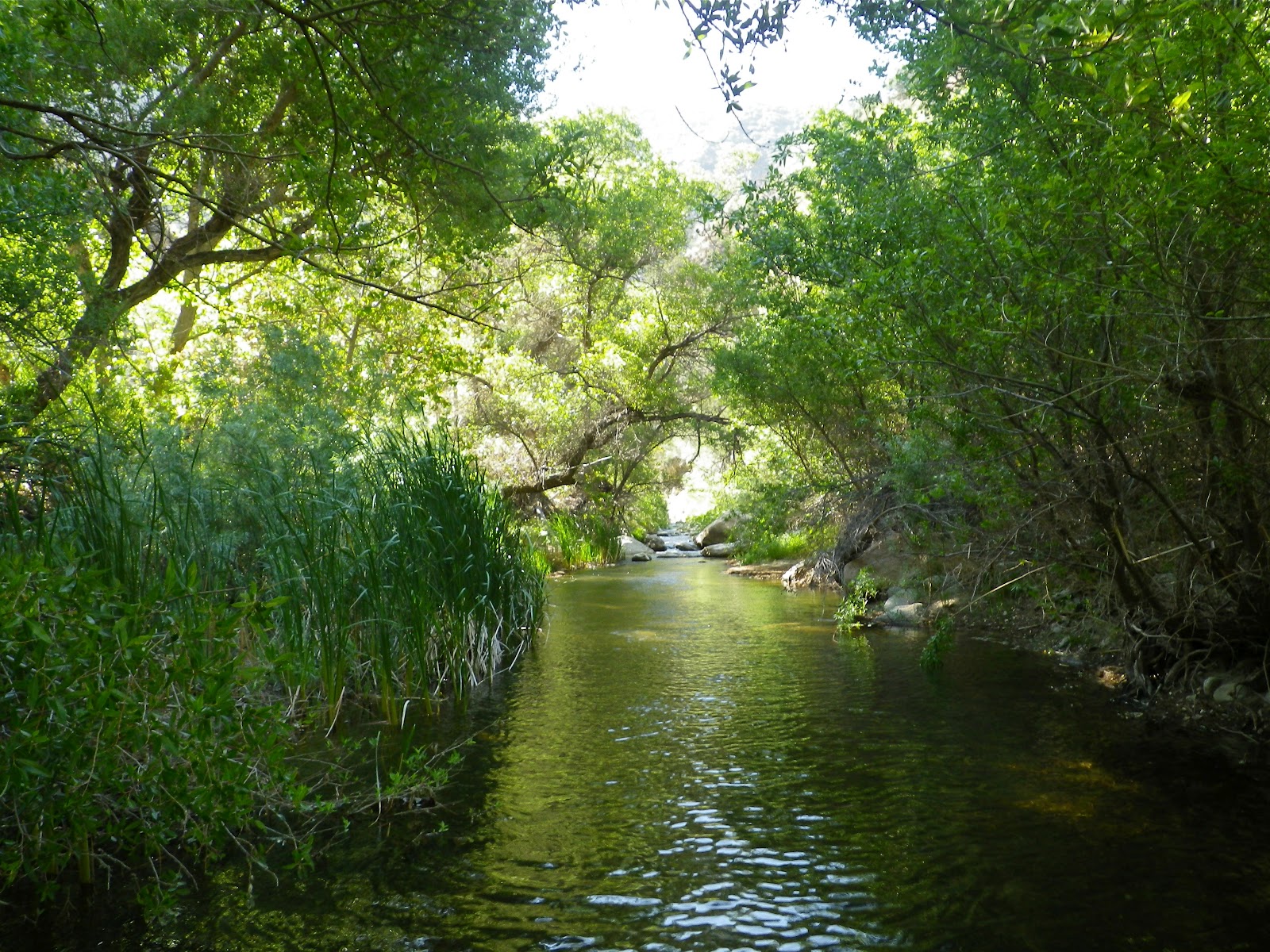
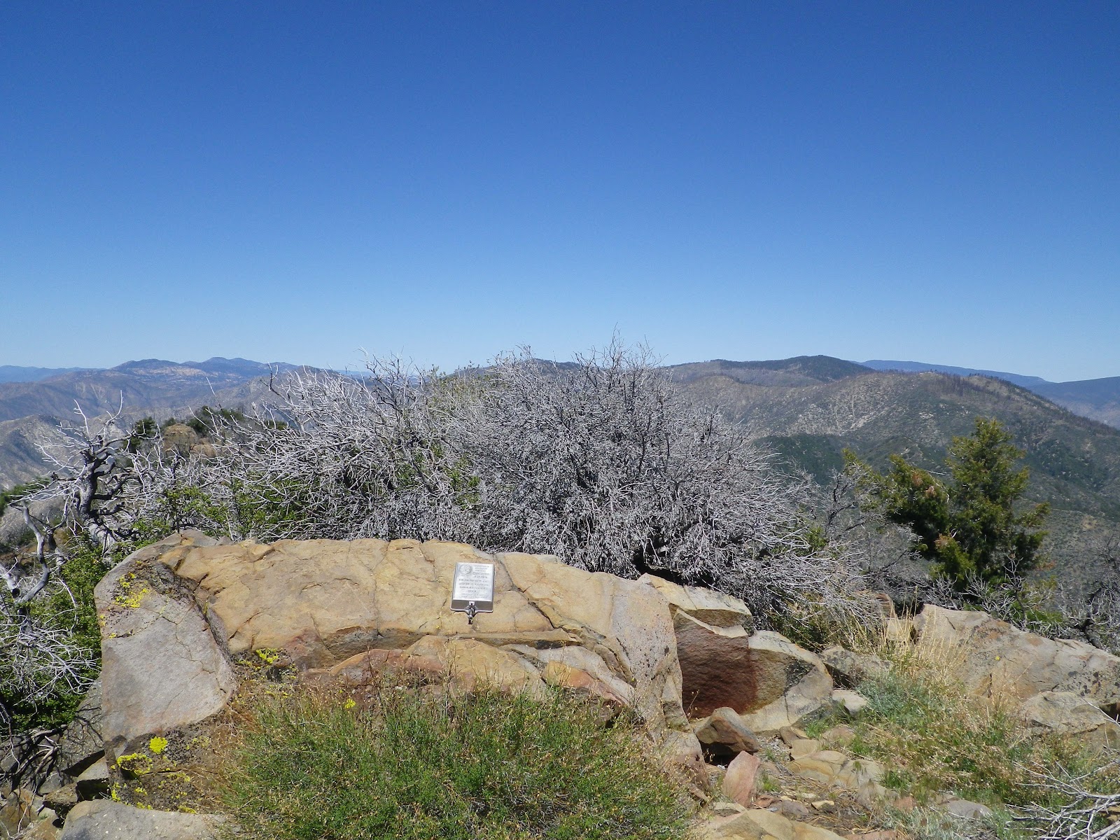
At roughly the half way point between the two lakes, the creek enters a stunning gorge, the likes of which I have not traveled. Nico put it on a par with another place he's visited above Santa Barbara, but I've been through the Big Narrows on Agua Blanca, Devils Gate, Devils Gateway, Alder Creek and the Sespe Gorge, and I found that this mile long gorge diminished those other narrows in my eyes. The Piru Gorge travels, like I said, about a mile through a slot that isn't ever any wider than 50 feet and averages a width of 20-30 feet. The rock is mostly a conglomerate of colorful cobbles cemented into the boulders and walls of this stretch. The walls of the gorge are curvaceous, with numerous pockets and alcoves at the creek level. In one place a small spout of water spills into the creek from 40 feet overhead. This is a true slot canyon, very pretty, and worth every step it took to get there.
 |
| Piru Gorge |
We spent some time appreciating the natural wonders of this remarkable gorge before continuing another mile further to the junction where Ruby Canyon drains into the Piru Creek. Ruby Canyon is rumored to have a couple waterfalls which wouldn't be in business now, at least there was no flow coming down the canyon. We did not investigate Ruby on this trip but I have a feeling I'll be headed up there at some later date.
We set up shop on about the only flat spot we could find that wasn't physically under water. It was a perfectly adequate place to call a halt. We'd been on the go since 04:30 due to the need for a car at either end of this route, and we'd been on the move for roughly 10 hours. Ruby Canyon on the Piru was a logical place to call it a day. As we each prepared our dinner du jour the sun had set, bringing forth a happy little cloud of bats, which are always entertaining to watch. I crawled in my bivy sac and thought about all we'd seen on this first of two days, and tried to put it to memory. It had been a big day filled with big adventure.
 |
| Sunrise over Ruby Canyon. |
 |
| Nico, back in the drink. |
In the morning, after the coffee was drunk and the visit from the skunk, we saddled up and moved out. We were back in the creek, feet wet within 10 minutes, head deep in brush shortly after. We followed the circuitous turnings of the canyon, in and out of the creek, up and down over rocks, etc... After about an hour of this we rolled past an old bee keepers site called Ellis Apiary and soon we were able to pick up fragments of the old Jeep track that linked the apiary to Lake Piru below. We saw some old iron implements, the remains of an ancient, rusted truck axle, and a battered gate circa 1940 that had been anchored into the rock of the canyon wall. We were now out of the brush and no longer near water. The road became a real road as we passed the entrance to Agua Blanca Canyon. Soon we rolled past the very pleasant Whitaker Ranch site and after that it was just a long, scorching walk out to the upper-most parking lot on the lake.


I can't say enough good things about this hike, but I am just about typed out here. Nico and I got along well on this trip, both relying on each other to find a way to get through this wilderness. I think I can speak for him when I say that this was one of those places that surpass all expectation. Just an awesome place.
On the drive out of the lake I experienced what I'm calling a "character building exercise". Both of us had driven up to the lake together, switched Nick's gear over to my truck, and drove back out. Entering the lake there is a kiosk which charges $13 for day use at the lake. After we'd dropped Nico's truck off we rolled back to the kiosk. I asked the really nice folks there if they'd mind refunding my $13 because all I'd done was drive in and back out. I explained what we were up to and they were happy to refund me. Now at the end of our trip and in Nico's truck, we drove out and he stopped at the kiosk. Nobody was in any hurry to come see what we were about so I suggested we keep driving. Nico took the high road and got out to talk to the folks at the kiosk. As he approached, a woman came out and shouted, "Are you my hikers?" and waved us through without charging us a second time. There's a lesson here and I suspect it's karmic in nature.


