|
| Jack deserves the credit for this map. I still haven't had the time to figure out Google Earth. |
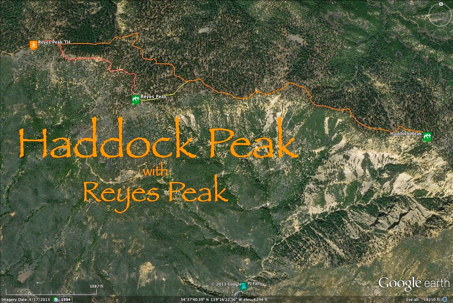
So I mentioned in my last post, after a day spent off-trail between Reyes Peak and Haddock Peak, that I had gone up with a specific reconnaissance in mind, to find a Class III-IV route down the west face of Haddock Peak and continue down the Potrero John (PJ) watershed to it's terminus at the Sespe on Hwy 33. PJ Canyon, when starting from the bottom is a pretty little slot. Bordered on both sides by high rocky walls, with PJ Creek flowing down middle among stands of oak and willow, the walk up PJ is pretty, quiet, and unfortunately, short. The PJ trail peters out after just 2 miles, and a bit further on it is completely obstructed by multiple waterfalls that are nearly impassable. People have always complained that Potrero John "doesn't go anywhere", which is true. Today I teamed up with
Jack Eliott and we found an adventurous way around that myth.
 |
| Morning fog over the Ventura River valley. |
I met Jack at 5am and we both drove up the 33 to the PJ trailhead where Jack left his rig. We continued up to the Reyes Peak trailhead and started the 5 mile walk to Haddock Peak, blazing through the forest until we were in the vicinity of Haddock's summit. After a break, we dropped into a narrow chute which I had decided offered the best chance of successfully descending into the drainage. It would undoubtedly be dicey, and there remained many questions about what we might encounter. We were looking down 4,000 feet of "death gully" to reach the road. Game on!
 |
| This is where we dropped in, a slot that I'd determined, after a thorough on-site recon, to be the best access to this adventurous descent. |
So, with great big brass ones clanging between our legs, we got to work. We dropped onto a steep slide which disappeared into a narrow slot. The slot was loose and rocky and we carefully picked our way down through the dirt, pine needles, and scree until the angle got steeper. We were only a few hundred feet below the Reyes Ridge when we were forced to actually start down-climbing this chute. The chute got steep here, at least 45 degrees of angle (or greater) and Jack couldn't help dropping rocks down on me. After about the third time a rock sailed past my head (I actually batted away a bouncing rock with a trekking pole), we worked out a plan that involved taking turns while descending. I'd go down a ways and climb off to the side, trying to get myself out of the bowling alley before Jack came down. This is good mountaineering practice and it mostly worked, except when it didn't. So far, so good. We'd been through some steeps but hadn't stepped above 3rd Class scrambling yet.
 |
| Jack, high on Haddock Peak. |
 |
| The neon green cliffs. The section in this photo is around 200 feet tall. These cliff bands get up to 400 feet tall and are clearly visible from Hwy 33. |
We continued down this chute that, on an alpine peak would be considered a couloir, something to be climbed or skied. We passed under the lichen encrusted, neon green bands on the face of Haddock Peak. These cliffs are highly visible from the 33. We'd followed this chute down about 800 feet from its take-off on the ridge when it suddenly split into two distinct channels separated by a rocky tower. The left hand split offered a vertical drop to a rocky slide 200 feet below. Fortunately, the right hand split was easily negotiable and a short ways below that we descended into an actual creek bed. A small stream of ground-water flowed here and we decided a break was in order. We sat in the sun, taking in the massive boulders, the pines, the songs of the morning birds. It was very easy to believe that I was one of perhaps a handful of people in human history to have seen this pretty spot. This place just isn't on anybody's dance card. There are several obvious ways up or down this face, if one has game. Our chute is in no way one of them.
 |
| Jack wants his privacy kept, but this was just too good a pic to not post so I pixelated his head, in case you were, you know, wondering? |
 |
| Parts of this chute resembled a luge. |
During our break we totally jinxed ourselves with talk about our luck thus far. From our vantage it appeared that we had about 500 feet more descent before getting to a point where all the various drainages off Haddock converge and become Potrero John Creek. Our chute wasn't the primary drainage. That larger drainage lay just around a corner to the east. I'd picked this way down because it was direct, like it got you there, and it had looked challenging. Jack and I just didn't have the good sense to keep our traps shut and that's how we encountered the first real obstacle of the day. We shouldered our packs and made it literally 200 feet down when I realized that our chute stopped, and that the bottom was very far away. I approached the edge of this waterfall with some apprehension, not because of the heights but because I could already tell there wasn't a way down this drop. On both sides were steep rock walls and the stone I now stood on ended in an 75 foot vertical drop to a gravel pit. There was no immediately obvious solution to getting around this problem. Hmmm. Most non-triumphant, man.
 |
| Looking back up our chute. |
I cast about for a fix to this dilema. Going down was out of the question because I don't like flying and haven't mastered those types of landings. The canyon wall to the right (west) was a steep shale scarp which didn't lead anywhere we needed to be. I looked at the canyon wall to our left, the direction that I knew would offer the best option for continuing downstream. This eastern wall offered me three options: 1.) climb up a knobbed conglomerate face to an unseen ridge (5th Class), 2.) face climb a high angle sandstone slab (also 5th Class) to the previously mentioned ridge, 3.) with the final option being an exposed traverse across a dirt face which continues around the canyon wall to who knew what. My eye immediately calculated which of these choices had the best probability of success and just as quickly I understood that all three options sucked equally. Crap. I really, really did not want to return to the Reyes Ridge in shame.
I climbed a few moves up the knobs which was going to be too steep and dangerous, especially for Jack who has no rock climbing experience. The sandstone slab was even sketchier, a fall from which would send the hapless victim down the very waterfall/cliff that had stopped our downward progress. Finally I was left with only the dirt "ledge" to an unseen outcome around the far slope. I tried it. It was sketchy and dangerous and offered no real way out of this mess so I tip-toed back to where Jack was hanging out and we decided to head back upstream a bit and look for some egress that could deliver us from this dead-end chute.
We climbed back up a couple hundred feet until we encountered a scree slop that got us pretty high up on the wall of our canyon. After a brief but scratchy manzanita scrum we stood atop a knife-edged ridge. We were now about 600 feet above the primary (eastern) drainage of Haddock Peak. It was immediately obvious that we were above the massive shale slide that is plainly visible from the 33, mid-way down Haddock. This ski slope goes at 45-50 degrees of angle and doesn't seem to have a bottom. So far it looked long and steep but didn't appear all that dangerous. We were wrong. This slope was basically a face of shale rock with some dirt scattered over it. This is not a reliable medium to do anything with and we very tentatively inched out onto this danger-face, headed for the lowest angle channel down the slide. A short time later we started going down.
 |
| The long and slippery, and blood-thirsty slope. Yeah, we went skiing without skis or snow. |
 |
| The damage form the slide continues up to the hip and on both arms. Is okay. Scabs are cool and chicks dig scars. |
As soon as I got started down the slope I realized that I'd needed to have as many points of contact as possible under me so I resorted to an undignified butt-slide with my feet splayed out in front of me and my poles planted wherever they might stick. Unglamorous in the extreme. Even with as much body contact as possible, and with all my skills, I was barely managing to stick to this slide. To make matters even worse, it became apparent that some ways below was a ridge of ragged stone sticking up followed by a six foot drop onto more of the same shale slide. To slip here would undoubtedly lead to injury so falling was not an option. While trying to stay glued to this slide I started inching a bit to the right with every scraping bit of descent. I was aiming for a small pine sapling far below but coming up fast. By that point I was only truly in control of my slide about 50% of the time. I was still 15 feet above the tree when I lost all traction. I still wasn't lined up with the tree and, gaining speed at an alarming rate, skin peeling away in individually exquisite shreds, I made a desperate roll onto my right side. I ignored my ripping flesh and lasered in on that little pine. I threw my arm out long, hooked the tree with my right hand, followed the momentum of my roll, pivoted my gravity onto that one arm and got my feet under me. As the dust settled I was swept through on a tide of adrenaline. That, my friends, had been sporty.
Jack managed to make the slide by implementing much the same technique I had employed. I was able to direct him down a slightly higher route which put him directly above my exceptionally beautiful and ruggedly sturdy prince of pines. Jack lost it about where I had and soon I was dodging rocks and spitting dust as he slammed feet first into our fine green savior. From the tree we were able to delicately traverse below the man-eating upthrust of rocks and eased ourselves into a shale slide that (gasp!) was actually made of shale. This lower apron of the slide was a piece of cake and we left a long plume of dust in our wake as we skied down.
 |
| Jack, dropping into the top of Potrero John Creek. |
 |
| The first waterfall of the day flowed from under this enormous boulder |
At last we dropped into the top of the creek, where the various run-off gullies of Haddock converged. We had finally arrived. We stood looking down a narrow watercourse fringed by oak and pine, choked with boulders the size of homes. We dropped pack for a while in the shade and took stock of our day. We sat in a completely remote fold of wilderness, listening to the trees sway and the birds call. It was all very peaceful. As we nibbled calories and replayed the previous hour's shenanigans I kept peering down that forested gulch, hoping we'd encounter no more challenges like the last.
 |
| Action Jack. |
 |
| The upper part of PJ Creek is chock-a-block with enormous boulders washed down from above. The gully itself was remarkably free of deadwood and debris. |
We got going again, trekking down the steep creek, descending into what became the most enjoyable portion of the day. The forested gully was free of debris and deadwood which made travel relatively easy. The ravine was at times wide open, then narrow and boxy. We encountered so many waterfalls in the next hours that we lost count. At least ten of these falls would have been right at home in Matilija or Tar Creek. Some were capped by massive boulders while others fell in broad horse-tail sheets. Others flowed sluice-like down steep and slabby cuts in the bed rock, very reminiscent of lower Tar Creek Canyon. This was great fun. We'd turn from admiring a tall falls that we'd just found a way down, walk a bit downstream, and encounter a new falls. Not only did we get to enjoy all these falls from above, beside, and below as we descended them, but I also got the fun of problem-solving our way down or around some steep and beautiful territory. It all felt very adventurous, just a few steps shy of being true canyoneering.
 |
| This is what the creek looked like between waterfalls. |
 |
| We encountered several hundred yards of this abandoned 1 inch hose, the remains of some half-assed mexican grow operation. This hose would be clearly visible from the air. |
 |
| Descending this was super fun. |
The vegetation changed from high and piney to oaks and chaparral. The creek transitioned through stages as well, and now, halfway down the mountain, the watershed had cut a deep ravine through sedimentary bed rock. I had a great time figuring out how best to get down these slots and slabs. As you can see from the pictures, there are some pretty big waterfalls in this drainage. It was just one impressive falls after another. Eventually we'd descended to a point high above the lower PJ canyon from which we could see far away and below to where the trail coming up from the 33 must be. We found a way around and down a tall, double-streaming falls and a bit below that we stepped up to the edge of what is referred to as Portrero John Falls (by this point in our day PJ Falls was just the last in a day full of impressive waterfalls).
 |
| This is the waterfall immediately above what is referred to as Potrero John Falls. |
So yet again we stood at the lip of a tall and dramatic waterfall, what we now understood was the last one of the day. Looking down PJ falls it was easy to see that there was no real way to down climb this nearly vertical drop of 70 or so feet. I was temporarily distracted from seeking another way down by an absolutely stupid rope system that somebody had left hanging over the side of the falls (see below). Jack really didn't comprehend my bafflement at this arrangement, not knowing rope-work as I do, but he understood just fine when I said that we were in no way using that rope as a way down. I took a good look to either side of the slot and sent Jack up and right on a narrow dirt ledge and through a small scrub oak and some yucca to see if my hunch was good. I knew that whoever had left the rope had to have gotten it up there somehow, and by deducing what I now knew about these people by their ignorant arrangement of the ropes (that they couldn't have been climbers), it was clear that there must be another, easier way up and down this thing. Jack soon reported that we had a green light down and minutes later we stood below the last of the waterfalls for the day.
 |
| Hanging off PJ Falls was one of the most amateur and backwards rope systems I have ever run across. They used a 10mm PMI dynamic (stretchy) rope to tie off to a boulder 40 feet above and away from the top of the falls, then used 2 locking biners for an additional length of black static (unstretchy) rope. Backwards. I'm sorry I left the system as it was. I should have torn it down. |
 |
| This is the actual PJ Falls one can easily reach from Hwy 33. Not so impressive when compared to some of the falls further up canyon. |
We transited through a rocky gully until we reached Potrero John Camp after which it was a pleasant and leisurely stroll out to Jack's truck. This had been a really good day, hard and rewarding work. I'd always kind of wanted to descend that big green face and rugged drainage that hangs above the 33. This turned out to be way better than I had any right to expect. It was another good day out with Jack. Dude's got game. He put a lot of faith in me from the moment I sprung the idea on him (I think I threw it out there less than 24 hours before we left). This was what I call a "danger day", definitely "Rated R", a day with numerous opportunities to die. I used all my tricks for finding ways down this thing and the reward was all there, even if I did donate blood to the cause. A fun day to be sure.
Here is my disclaimer: I
do not recommend that you, the reader, try this route, but if you do choose to go, at least have the good sense to be good at this sort of thing. It will let you know if you aren't.
 |
| Going out through the in door. |