Showing posts with label Samon Peak. Show all posts

Thursday, January 10, 2013

Samon Peak (HPS) 01/08/13


Back in November I took a good shot at Samon Peak. Unfortunately, it had been raining on me that entire morning and as I ascended the ridge to the summit I got twisted around in a cloud, suspected that the GPS was lying to me (known as "bending the map"), and generally failed to summit. Not that I didn't enjoy the day, but that was a lot of walking just to spend the day wet. 
Redemption day. I got out of bed at 02:30 for the two hour drive to Santa Barbara Canyon. Ruth kind of woke up for a second and mumbled something about her husband's sanity before falling back to sleep. I staggered out the door, turned the ignition and started my day.
Stepping out of the Perseverance (that's the name of my truck, Davi Rivas' truck is called the Endurance) I sucked in a full lungful of shockingly arctic air. Jeezus it was cold! The gauge in the truck said I'd be starting with temps in the 20's. Brrr! There wasn't a lot I could do about that other than start walking. I got going a little after 5AM on what would be a 23 mile day.

The only noise in the cold dark air was the metronomic crunching of my footsteps. Buckhorn Rd had started out a mixture of frozen mud and snow, but as I climbed it's twisting miles my path became increasingly the latter. The cold seeped up through my soles, pushed it's frosty tendrils through zippers and pockets. It usually takes me a good mile or so to get all the morning kinks and bullshit out of the way. Between the watery eyes, numb toes and runny nose I was finally able to get my act together and start burning up the road. 
Junction: Buckhorn Rd and Sierra Madre Rd
Buckhorn Road is long and tedious. And boring. I passed the junction of Buckhorn/Sierra Madre as the eastern sky started showing signs of the coming dawn. I killed the headlamp and kept walking. Now that I was up in the high country, and with the sun rising, things got beautiful. I started really enjoying my walk. I consider myself somewhat of an amateur tracker, and with 3-6 inches of snow on the road I was able to entertain myself with the unending variety of animal sign. Tracks I saw during the morning include coyote, deer, elk, feral cow, mountain lion, bear, bobcat, some kind of weasel, raccoon, rabbit, and several bird species. I enjoyed silhouetted views of Cuyama and Madulce Peaks, but what really grabbed my attention was Samon, my reason for being here. I had rounded a twist in the road and all of a sudden there was this enormous ridge, the skyline of which was rough and rugged. Looking at it from the north I could visualize almost the entire ridge to the summit and I was reminded that I had been up there somewhere just 2 months ago, wet, wandering. I wasn't going to let that happen to me again.
Ice crystals in the road bed.
Madulce Peak in the distance.
Samon's summit ridge.
Crunch, crunch, crunch. Punching holes in snow. The sun was up now and the GoreTex in my kicks couldn't keep the wet out. About 9.5 miles into the morning I finally reached the take-off for the ridge to the summit. This "trailhead" lies 1-2/10ths of a mile north of Chokecherry Spring and is poorly marked. I should say that on a good day this trail can be a bit mystifying, add half a foot of snow and everything starts looking the same. So I can say that most of the climb from the road to the ridge I was winging it, but eventually I cleared that first climb and continued west across a small meadow on the north side of the ridge.
Samon peak with the telephoto lens.
This is the highly marked and immediately visible take-off for the summit.
Past the meadow and up on the summit ridge for real I continued west along the undulating crest. This is another one of those peaks that don't seem to get a lot of traffic and so the trail along the top of this ridge is mostly overgrown and the route itself is pretty tough. After cresting a series of three small summits I was presented with the last short grind to the top of Samon.

The last step to the summit.
Atop the summit I was greeted to 360 views ranging from the Sierra Madre to the north, the Sisquoc Condor Santuary to the west, Big Pine Mountain to the south and Madulce and Cuyama peaks in the east. Quite a view from up here. Turning to the summit benchmark, those that have been know that the crew that placed the benchmark here misspelled the name. That's kind of fishy, but funny. The old coffee can register goes back a ways and there are a few names in it that I recognize from other summit logs in the SLP. This is a nice summit, well earned, and just parked way the hell out in the middle of nowhere.

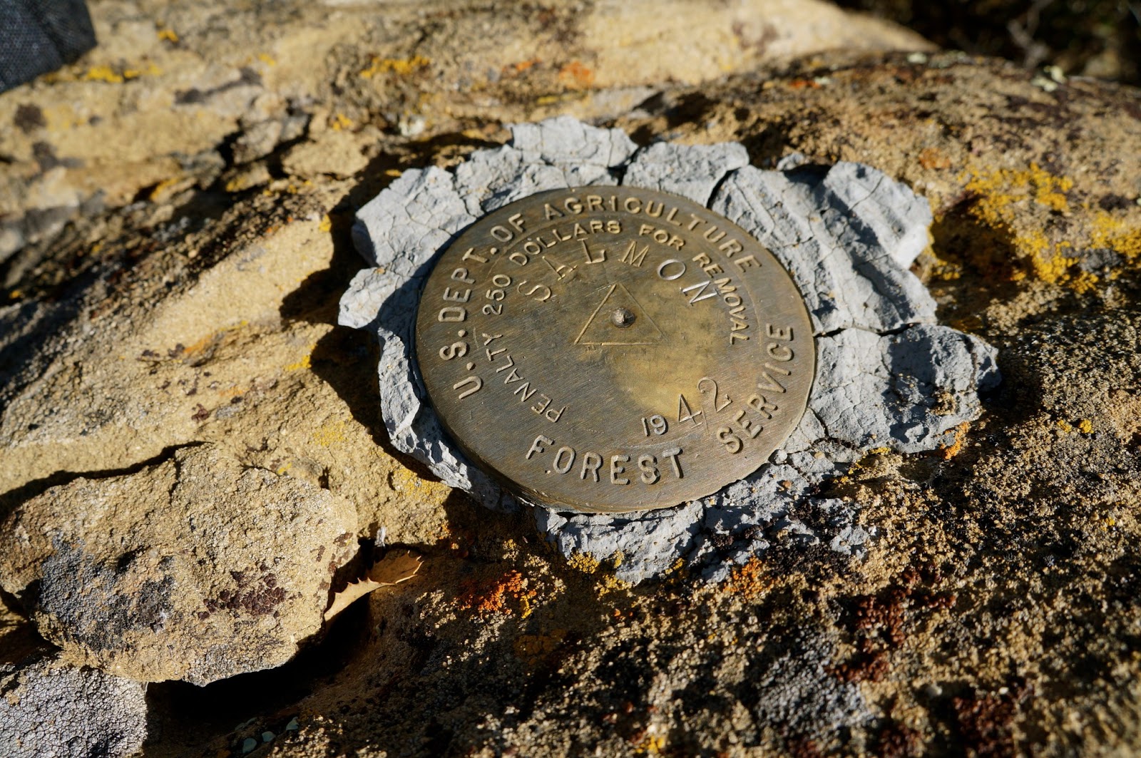
Samon Peak, misspelled.
After some lunch and play time with my shiny new camera it was time to depart the high realms and resume the second half of this day. I reversed my route, struggling through the same snow and brush that fed me on the way up. Just so you know, this ridge is a lot like work. Add snow and mud and it starts feeling just hard.
Looking back along Samon Ridge from the summit.
Back on the road I turned north and started the long trek out. The snow on the road was getting slushy and as the hours rolled by, the snow and mud became a real pain in the ass. The rest of the afternoon was a muddy mess, the kind of mud that sucks at your heels and globs up on your shoes to the point that they weigh like 5 pounds. Sucky, but for all that it was a long and pretty day. Good peak.


Muddddd.


Monday, November 19, 2012

Samon Peak... I think? I'll explain. 11/16/12

Evening in Cuyama Valley

Okay, well here's a weird one. I thought I had summited Samon Peak while out and about last Friday. The GPS said I did, and I believe it, but by that time I was so deep in a cloud that I couldn't find the summit marker or the register. And that's the sucky truth. I'm not at all confused about where I was, just that I didn't, as they say, get the t-shirt. Aside from that I had a very nice 25 mile day in the rain.

Madulce Ridge with the summit lost in the clouds.


A sunrise laser beam aimed at Madulce Peak

When I took to the hills on Thursday evening I was well aware that the forecast was not favorable for the type of day that I had planned on. I decided instead to take a crack at Samon Peak. To that end I pre-positioned myself up Santa Barbara Canyon for an early morning start. I parked at Willow Flat instead of at the eastern gate for Buckhorn Rd. Willow Flat is a lot like Grassy Flat on the Sespe in one respect...the names are no longer relevant. See, Grassy Flat is neither grassy nor flat, and Willow Flat has only a nappy old juniper tree. I guess things change. Anyway, I parked it here instead of another half mile up the road in case I decided to link Samon with Madulce and come out through SB Canyon. It didn't work out that way but whatever, I had a great day.

Here's the "meadow" that's mentioned in route directions for Samon Peak.
I crawled into the bed of the truck and knocked out early under cloudy skies. When I woke at 0300 the first thing I noticed after killing the alarm clock was the rain. Oh good. Crawling out of a warm bag and into shell gear at 3AM isn't anything new for me, but I'd rather it was snowing. I have a feline nature and part of that is an antipathy for being cold and wet. I don't enjoy those two things when combined. And especially without coffee. Already 2 strikes on the day. No coffee to be had so it was Go Go Gadget Gore-Tex! time. I got myself put together pretty quickly and was out the gate at 0330. In the rain.


It was a black morning. And did I mention it was raining? After a mile of chasing the beam from the headlamp I was pretty warmed up and feeling about right. I hit the gas and started trucking up Buckhorn Rd. This road is one of those routes that I prefer doing in the dark. The road is smooth and foot friendly with very few rocks, which makes for easy walking. Also, it's just better to not be able to see how steep the first five miles are and how far away the various loops in the road are. I have heard that this long and tedious grade can be bad for morale. I know this route pretty well and I let the miles fall by while listening to the rain fall on my hood. It was a peaceful walk, quiet. I enjoyed the climb for what it was.

Anybody know anything about an old telegraph? wire strung on the high south shoulder of Samon Peak?
At the top of the grade I headed south, following Buckhorn Rd. The sky began to lighten in the east but overhead was a solid ceiling of ominous clouds coming in from the west. Now that I was up above the canyons I was greeted by a persistent northerly breeze that came on at 10-15mph and never seemed to go away. The wind and the rain seemed to get along like old friends, lucky me. At sunrise the first rays of light cut a straight line under the cloud ceiling which was a neat, if too brief show. Soon enough the sun was behind the clouds and my day returned to dripping grey. As I neared Chokecherry Spring I started keeping an eye out for the use trail which leads to the summit of Samon. That junction is currently marked by twin yellow hazard tapes, 1-2/10's of a mile north of the spring.


I couldn't make out much from the start of the summit trail. The clouds ceiling was now less that a hundred feet above my head. Wind, rain, and pretty soon I'd be up in that cloud. How damn exciting is that? Up I went. The lowest portion of the summit trail ascends the northern side of the ravine that drains to Chokecherry Spring. After a brief, steep and brushy climb I traversed WNW across the small meadow that's mentioned in all the guides, and continued climbing the route up the NW side of the ridge. So far so good. I was soon in the clouds, drenched on the outside, breathing water, huffing up this steep and muddy track. I finally popped out on a high saddle with one arm of the ridge heading south and the summit ridge a short ways up and right. I waded through the cloud until I ran out of places to go up, and this might have been a little comical to an outside observer. I wandered all over the top of that thing, looking everywhere for the marker, but the cloud was so thick that I couldn't see more than a foot or two. As I mentioned above, the GPS said I was there. What I remember of the summit (and I fully expect to be told by some of you that I may or may not have actually been there) is a rocky pile of broken brown rock, about 8 feet on a side. West of that pile, and down hill about 15 feet is a second, smaller pile of the same rock. If this ain't the top of Samon Peak then I need a new GPS.

Samon Peak. I was somewhere up in that mess.
Buckhorn Road.
Buckhorn Road.
Buckhorn Road.
 
After wandering around in the cloud a bit I headed over to the south pointing shoulder I mentioned before. I followed a bear track out that way for a while, and was surprised to find the old wire and glass insulators strung along the ridgeline's length. As for the summit, I'm completely comfortable with the idea that I have to go back in better conditions. I liked the peak but I just couldn't find the marker in all that cloud.

I abandoned the peak and descended back to Buckhorn, hit the gas and got outa there. From below the clouds I could see patches of sunlight to the north. That's where I wanted to be...out of the rain dammit. I just rolled on out to the long grade back into SB Canyon and the end of the day. I had a great time out there despite the weather. Some days are just wet and windy and you can't do anything about it except stay home. I guess I'm not that guy.

I figured my exertions at around 25 miles for the day, which took me 10 hours to accomplish. I'll be back to sign that summit, next time I'll wait for a clear day.