The Longest Day.
22 miles in 21 hours.
12 miles navigating the Sespe.
Summit Devil's Heart.
First Ascent Coronary Couloir.
Still haven't found the Breaking Point.
No longer wish to.
 |
| Detail of entire route. Click any image to enlarge. |
 |
| Detail of Devil's Heart Peak, Coronary Couloir, Class III |
The urge to climb Devil's Heart goes back to my excursions on
Topatopa Peak and
Sulfer Peak. From Sulfer Peak I first saw the huge gash on the eastern side of DHeart that presented a possible route to the summit. From atop Topatopa's rusty tower I had been able to see straight down to DHeart's rocky crown and I understood then that just this little distance between the two peaks nudged Devil's Heart into an even more select handful of uniquely remote SLP peaks. Peaks that nobody does.
I still consider myself a mountaineer and climber first. If an alpinist wants to go somewhere, he finds a route that'll get him there. Alpinists don't think like hikers and therefore they are not constrained by need for trails. They have the keys to their own freedom. They will generally pick the cleanest, most direct, and most aesthetic ways to reach their goals. This is how the idea for Coronary Couloir was born.
My window of opportunity for accomplishing this goal was narrowing. The further we moved into spring and summer, the less likely I was going to be able to pull this off. I'd tried to get others to line up with me for this weekend's effort but to no avail. This last weekend was simply the best time that I could make this work. I'd have most of a full moon, low water levels, and perfect temperatures. I couldn't put this off any longer in the hopes that conditions would be as favorable sometime later. Time to go.
I started from the Tar Creek trailhead a 05:00 on Saturday morning. Scorpio hung low in the southern sky, arcing above the ambient light of Los Angeles. The morning was cool, the scent of chaparral and glint of starlight my only company. That, and the crunch of my footsteps. I felt good, like I could do this thing I'd laid out for myself. I descended into Tar Creek and turned downstream, following that canyon down to it's terminus on the Sespe, where the real work would begin.
 |
| First light on the Sespe Rock Garden. |
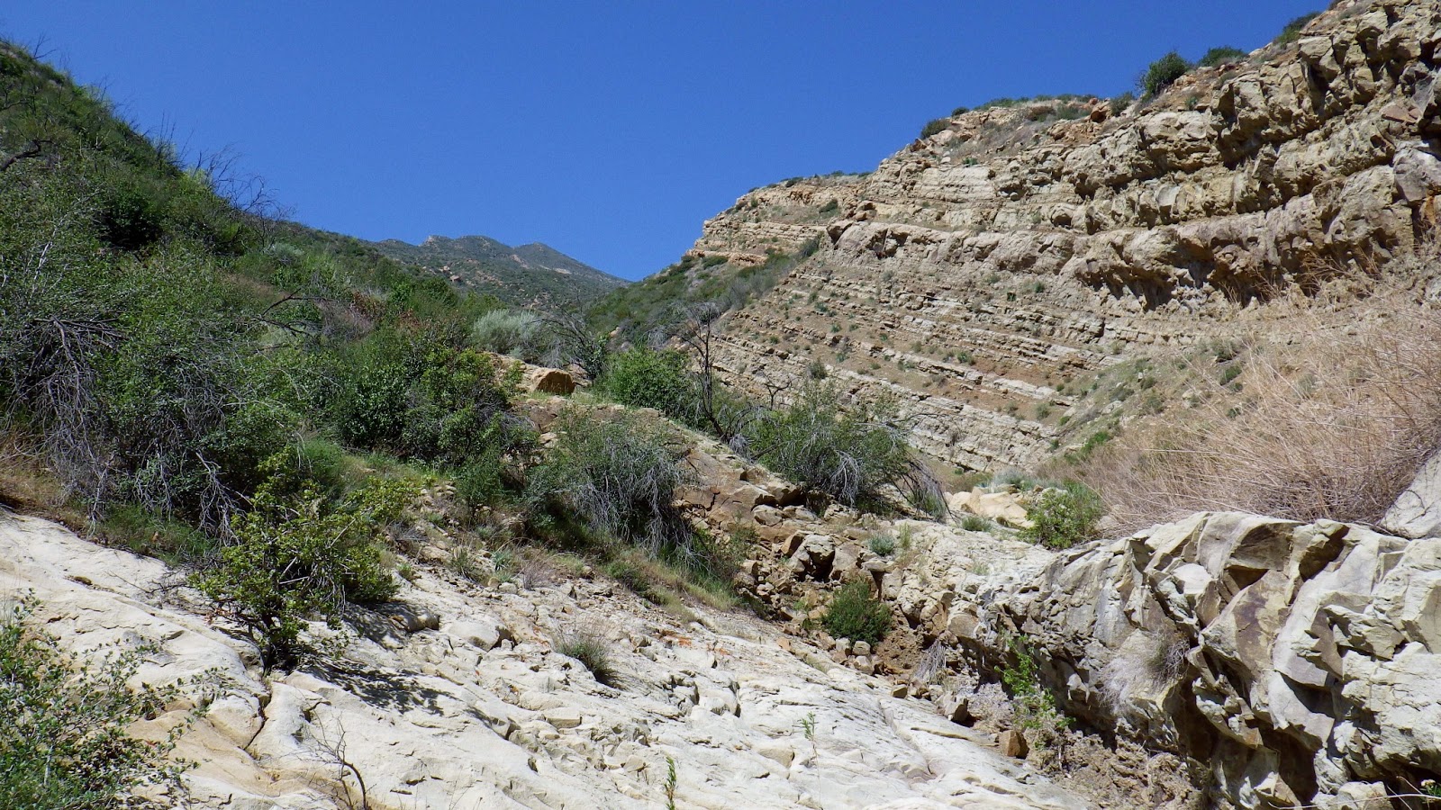
Those of you who've travelled down the Sespe probably recall that it felt long and arduous, a combination of swimming, wading, rock hopping and creek bed slogging. That it didn't seem to end. That you probably didn't want to see another rock for a while. Now take all those recollections and apply them to going upstream. Against the current, scrambling up rocks instead of down them. I knew this next 6 miles were probably going to be the most tiring work of the day. And it was. Late in the morning, still wandering up the Sespe, I got my first look at Devil's Heart.
 |
| Tevas and Seal Skinz. A good combo for this creek stuff. |
 |
| Water levels in the Sespe were okay, which worked out well for me. |
 |
| The first glimpse of Devil's Heart, high and left. |
 |
| Done with the creek for a while. Next, the summit. |
I had finally passed through the aquatic boulder garden known as Sespe Creek, reaching the bottom of the drainage I'd be ascending at around noon. I was feeling pretty battered by this time, "beat to shit" might be a better way to put it. Under the blessed shade of a tall maple I recharged myself with a massive infusion of carbs, protein and water. After filling my water bag I rose on trembling legs, swayed into my pack and got going.
 |
| The entry to the Coulior. |
I started up a broad gully that soon became bunched up with brush and trees. The first of the three stages that this route can be broken down into was somewhat frustrating. I found out the hard way that this lowest section of the drainage is where multiple smaller drainages converge before pouring down a brief set of slabby chutes. The chutes were easy, but above them I wasted time and energy mucking around in the runoff branches before identifying the right way into the endless open booked chute above. Eventually I scrambled out of the brush and up a loose face, cracking a smile as I looked up to see more than a mile of gentle skyway arcing to the summit.
 |
| Slabby chutes, lower section. |
 |
| Looking back down the brushy and confusing lower section. |
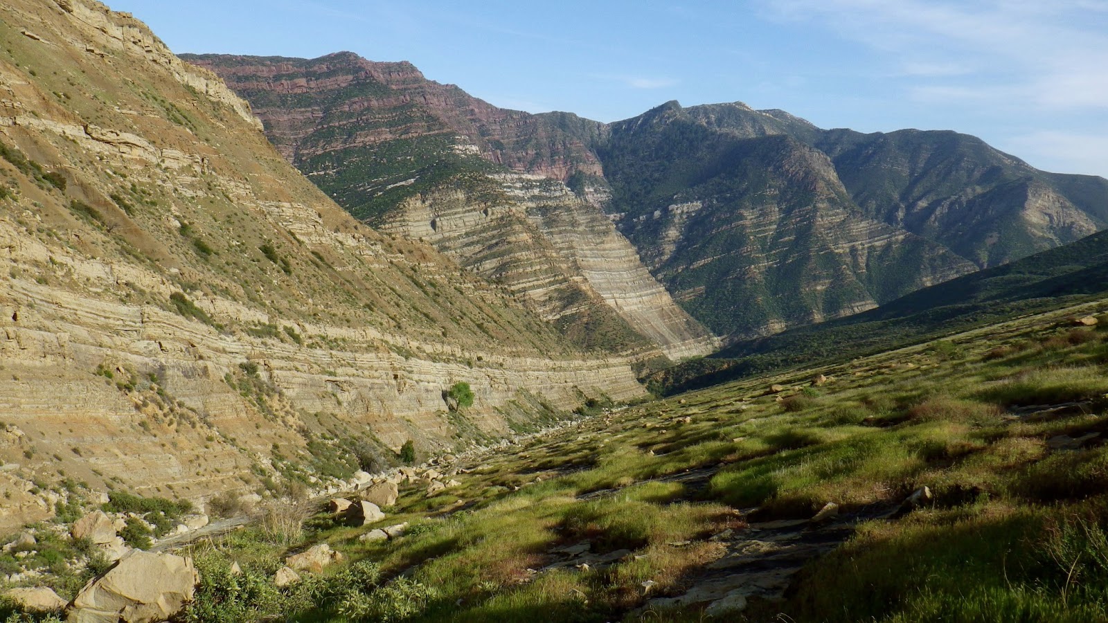
I had cleared the first obstacle and gained access to a really beautiful and unique slice of the Los Padres. All of a sudden the day had been worth it. I climbed a V-shaped chute, the left side of which sloped into the drainage at a friendly angle, an open sheet of sandstone graced with patches of green and golden grasses. Rugged bands of sedimentary rock hugged the right hand side of the massive "V" all the way up. Moving a bit higher I climbed out of the gully's scattered brush and entered the giant chute For the first time this day I was really having fun.
 |
| Grand Scale. Still some brush in this lower part of the Couloir. |
 |
| A wide open path almost all the way to the summit. |
 |
| This thing just keeps going... |
 |
| ...and going... |
 |
| ...and going. |
After the long and gentle, open and carefree ascension of that pleasant drainage I was unenthusiastic about what I was certain would be a final, brutal brush fight to the summit. But I had it to do. I peered upward through salt crusted sunglasses and suffered the days first real moment of self doubt. Brush. Overhead brush. Fuuuuck. I continued upward as the drainage narrowed to a rocky, brush choked gully. This went on for a while before I was able to find a steep exit which might take me to through the brush to the summit. I off-routed myself by exiting too soon, climbed a couple hundred feet through some brush before realizing that I'd left the the drainage too soon. Cursing myself I reversed that elevation and put myself under the summit. I nearly quit then. After a check of the gps, I rallyed for the last brush haul to the summit.
 |
| After the second moment of despair, the gps told me to keep going. |
 |
| Pinpointing when is the right time to leave the gully and push for the summit can be difficult. |
 |
| Finally, the last bit to the summit. |
 |
| Looking toward Filmore. Sulfer Peak in the foreground. |
 |
| Left: Cobblestone Pk. Right: Whiteacre Pk. |
 |
| Like, Yay! It's like, 3pm and I'm like already halfway thru my day! |
The summit of Devil's Heart is small, rocky, encrusted with condor piss. There is no benchmark or register. I stayed less than 10 minutes, taking time only for a few pictures and to leave my calling cards. I cannot speculate on what date this nob might have last been visited. I can't find one shred of evidence that anyone has ever been here. Upon summiting my priorities shifted. My new goal was to get back to Tar Creek as quickly as possible before I found myself thrashing about on the Sespe at night. Time to go.
 |
| Descending the couloir. |
I turned tail and fled back down the peak. My new mantra, "Gotta get out, get the fuck outa here." I found my stash of extras I'd left on the Sespe, switched back into my water shoes and resumed travel. Going downstream was a big plus. I was probably taking half the time to descend what I struggled to get up this morning, oh so long ago. I kept moving, replaying the mantra. Somewhere in the early evening I got "Invisible Sun" by The Police stuck on an endless loop in my head. It could have been worse (it can always be worse). I was using the headlamp and moonlight an hour before reaching the old Tar Creek Trail, relying on the gps to help me find it. Nightfall on the Sespe was truly a beautiful and unique experience, one I took pains to notice and appreciate despite my own pain and fatigue. I won't forget that night walk down the Sespe.
What I would like to forget is the hike out on that old Tar Creek Trail. I got all jacked up on that stupid trail and lost the route several times, costing an extra hour of effort and misery. A sea of brush in the moonlight looks exactly like that, a rolling sea of brush. And if the trail isn't obvious, it's easy to wander off.
I'm not going to attempt to give you a complete rundown of the aches, miseries, agues, and trauma incurred during this effort. Most of you who've been in that neighborhood can look at the map, put two and two together, and figure out that this wasn't easy. But the route is good, or, parts of it are great and the rest of it goes.
A special thanks, to Davi Rivas and Darren Ogden who were awake and concerned when I was finally able to contact them at 02:30 on Sunday morning to say I was fine. They'd actually thrown packs together to come looking for me if I hadn't been heard from by first light (which was the deal). Also, thanks to Nico for being my third back-up man.