
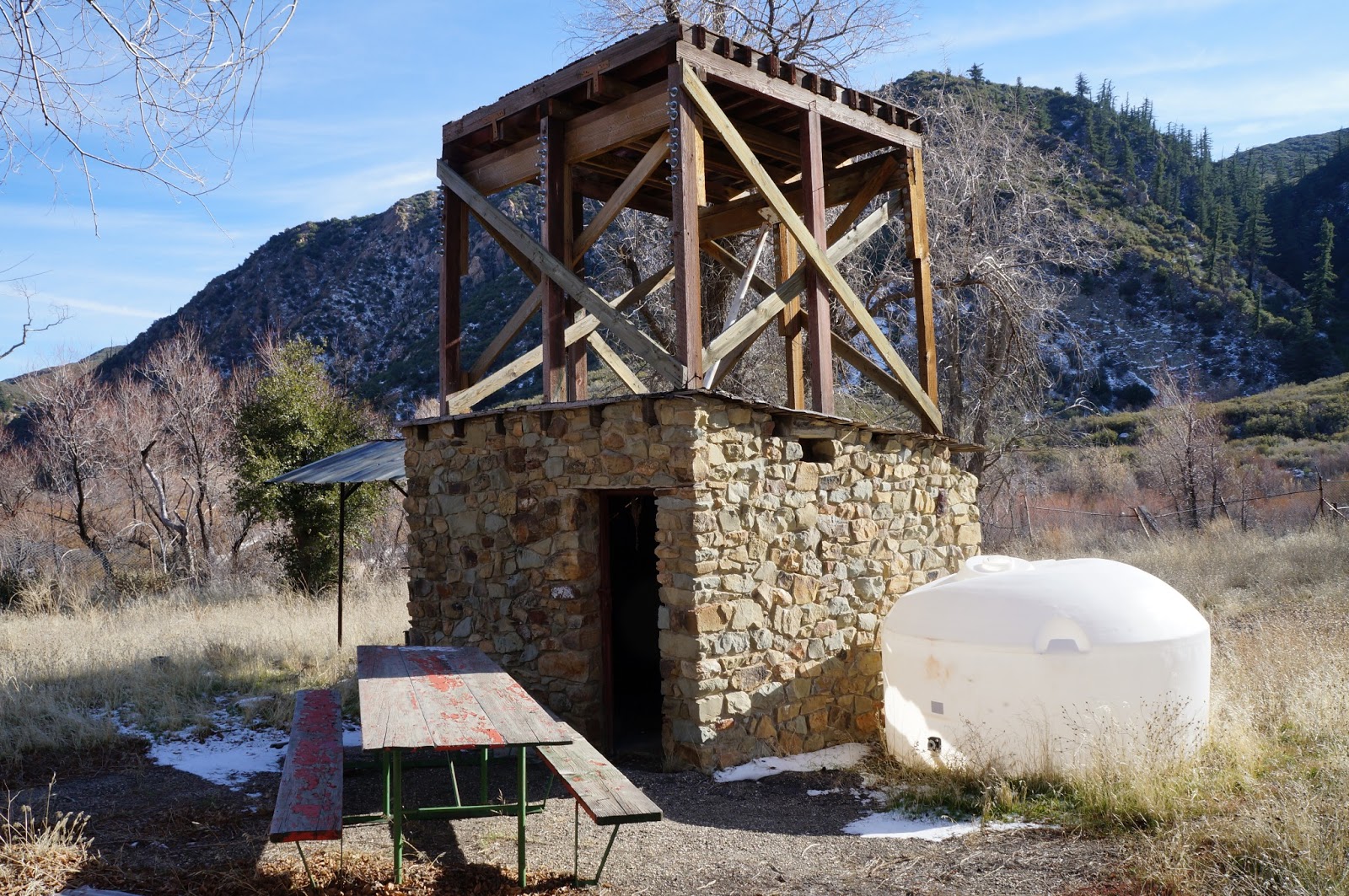
There's been a death in the family. Lookout #6 fell down.

If you'll all remember what Sunday the 13th felt like you'll recall that it was just extra cold. I'm generally pretty adaptable to temperature extremes but some days I start feeling my age, my real body age, not just the number. I've had some pretty good crashes over the years and sometimes when the barometer swings wildly I feel it all coming home to roost. This was such a day. I wasn't interested in a lot of hiking and running and jumping and crap. I put together a quick plan that accommodated my achy pity party. On the agenda was a drive up to the old lookout on Cuyama Peak.
The Sierra Club Angeles Chapter Hundred Peaks (HPS) list Cuyama Peak as one of their suggested peaks. I don't know why but this bugs me. First, there's an open, ungated road to the top. Second, there is no single-track alternative to the road. Third, the HPS says to park at the take-off for Tinta Canyon and walk up the road to the summit. This walk is only 2.25 miles. It's silly, contrived, a gimmick. Drive way the hell out to Santa Barbara Canyon and 9 miles up Dry Canyon to walk 2.25 miles up an ungated road? Even the route up Reyes Peak is more legit. At least it's a trail. So I figured if I wasn't in the mood to walk I might as well check out this old tower. And that's how I discovered that the lookout ate shit. To get some backstory on the tower and see images of what it looked like not that long ago, see Craig Carey's write-up.

So I had too much fun 4X4ing up the road in mud and snow. It's nice to have one of the more capable off-road vehicles to drive off a lot. I had to drop into 4-Low for the last mile to the summit. On top there was a chilled couple who had spent the night on top. I was a bit baffled by that, but they were great people (for the life of me I can't remember their names dammit). They gave me coffee and bacon. He's a Ventura County firefighter and she's a student at the zoo sciences school at Moorpark College. Good people, even if they were nuts to over-night on top in this weather. Wish I remembered their names.
After a few minutes chatting I walked over to the tower. The whole cabin structure had simply collapsed to the north. Snow had blown through the entire thing and the whole platform was a mess. Down below is the remains of the old cabin. I didn't even sign the register at the tower's base. Most of the entries were written by deer hunters or guys with motorcycles. Like I said, walking up here from below just seems silly, but I didn't do it, which is why I didn't sign the ledger.


 |
| The old ground-level cabin. |
 |
| A view north. |


Done with the tower I followed some prints off the eastern side of the summit. I spent some time reading the tale of a puma stalking a deer down the mountain. This cat had a 5" foot which puts it at at least 115 pounds. Not a kitty you'd want to meet.

I drove down Cuyama Peak and back into Santa Barbara Canyon where I did a little looking around. I satisfied myself that I had located the take-off for Fox Mountain, for future reference. And I scrambled over, under, around and through the red rock bluffs above the SB Canyon Ranch. I'd always told myself I would someday check out these impressive bluffs. Under the bluff I found a huge pile of owl droppings, fallen from a sheltered alcove 50 feet overhead. On top of the bluff I got these awesome pictures of Bob Reyes' private Idaho. He's a nice guy. Talked to him for a bit after coming out of Madulce a couple months ago. The Santa Barbara Canyon Ranch has been in his family for generations.
 |
| Collected owl droppings. |


 |
| This is just damn pretty. Atop the red rocks at Santa Barbara Canyon Ranch. |
I eventually headed home, but I pulled out for some particularly scenic things I had to shoot. I also stopped at the old Chorro Pack Station.
 |
| Cuyama Peak Fire Lookout from near Quatl Canyon |
 |
| Pistachio Trees, Ventucopa |
 |
| This is the main room and fireplace of the Chorro Station on Hwy 33. |
 |
| Chorro Pack Station |


I mountain biked up the Tinta to that tower in late 2011, that was a blast, sad to see the tower collapsed now. When I was up there last there were bugs falling out of all the wood, it was pretty nasty.
ReplyDeleteAloha Chris,
ReplyDeleteI admit I don't envy you cranking up that road to the summit. Yeah, wished I'd gotten out to that tower 6 months sooner.
Hey, I'd like to get your info again. I never really got a chance to look at your stuff and I think I deleted the link.
-DS