Showing posts with label Peak Bagging. Show all posts

Monday, February 24, 2014

Cobblestone Mountain via new route, "Redrum Ridge"


The idea for this new, southern approach to Cobblestone Mtn came from Jeff Cannon of Newhall. He thought that the route ought to be called the "Southwest Spur", which (no disrespect to Jeff) is kind of boring and benign, and while the climb up this ridge is many things, it is neither boring nor benign. After my attempt on Valentines Day (trip report) and again during this climb today, I was reminded that there is nothing humble about Cobblestone Mountain. I have now earned this route, and I am christening it Redrum Ridge. Those of you who haven't see The Shining can simply spell "redrum" backwards and it will all make sense.

There are two elements beyond human control that make this ascent possible. 1.) There needs to be water in Agua Blanca Creek for this to work. I went through close to eight liters of water for the entire day, 4.5 of which went down on the actual mountain. 2.) The temperature has to cooperate. The entire route climbs the southern aspect of the mountain. There is very little shade anywhere along the route, and this part of our forest tends to be devilishly hot even when other areas feel cool. If those items are in order then one can focus on the mountain.


Click any image to enlarge it.

I once again knocked out the eight miles to Ant Camp in rapid style, stashed some items, topped off on water, and set about climbing this thing for real. The use trail which crosses the meadow NE from Ant Camp leads to Agua Blanca Creek, and by crossing the creek and going downstream for about 150ft one arrives at the start of the route. The climbing starts immediately, ascending the left side of a steep canyon of grasses, yucca and low scrub. Gaining elevation, one eventually clears the canyon and begins to wrap around the upper portions of this first hill. It is best to angle NW across this slope until crossing a small gully, then up, up, up to the mother of all ridges.

This detail shows the lower portion of the climb ascending to the ridge.
The big slope which climbs out of the gully to the ridge is a grind. The slope is hot, loose, and a bit brushed up. This part of the climb is long and steep and it sucks. After attaining the ridge one gets a bit of a break. The top of the ridge from this point is large and rounded, and though it too is brushy, meandering upward through the scrub is not difficult. The route continues up this ridge, climbing two short steps before reaching the first red dot noted in the image below. To the north of this dot is a minor saddle where about 150ft of elevation will be lost. To minimize this loss, and to get some time in the shade on the north side of this lower part of the ridge, I shortcut across the northern aspect of the ridge below the red dot using a pretty good animal trail. Below, on the saddle is another opportunity for shade in some pines, a time to gather oneself before attacking "The Three Evils".

Detail of the mid and upper ridge.
Elevation profile from Agua Blanca to summit.

The 3 Evils. Three steps, each longer than the last. Each climbing at between 30 and 50 degrees for their entire length. This part of the ridge has a character all it's own. Steep, rough, rocky and loose, with old pines dotting the narrowing ridge. The first time I ascended these steps the experience was soul crushing. On this day though, I was out for revenge, attacking each step with raw determination and brute force. Hostility might be the best word for it. I knew what I was in for and I brought my game face. On a hard mountain this stretch was the hardest. One gets a bit of a break after topping out on the second step. Here the ridge turns northwest, cresting and dropping over a couple minor rises before settling once more into a steep climb which wanders around intermittent stands of charred brush. My tracks fell in amongst the tracks of an enormous mountain lion, and figuring he knew where he was going I let him lead me almost all the way to the summit.
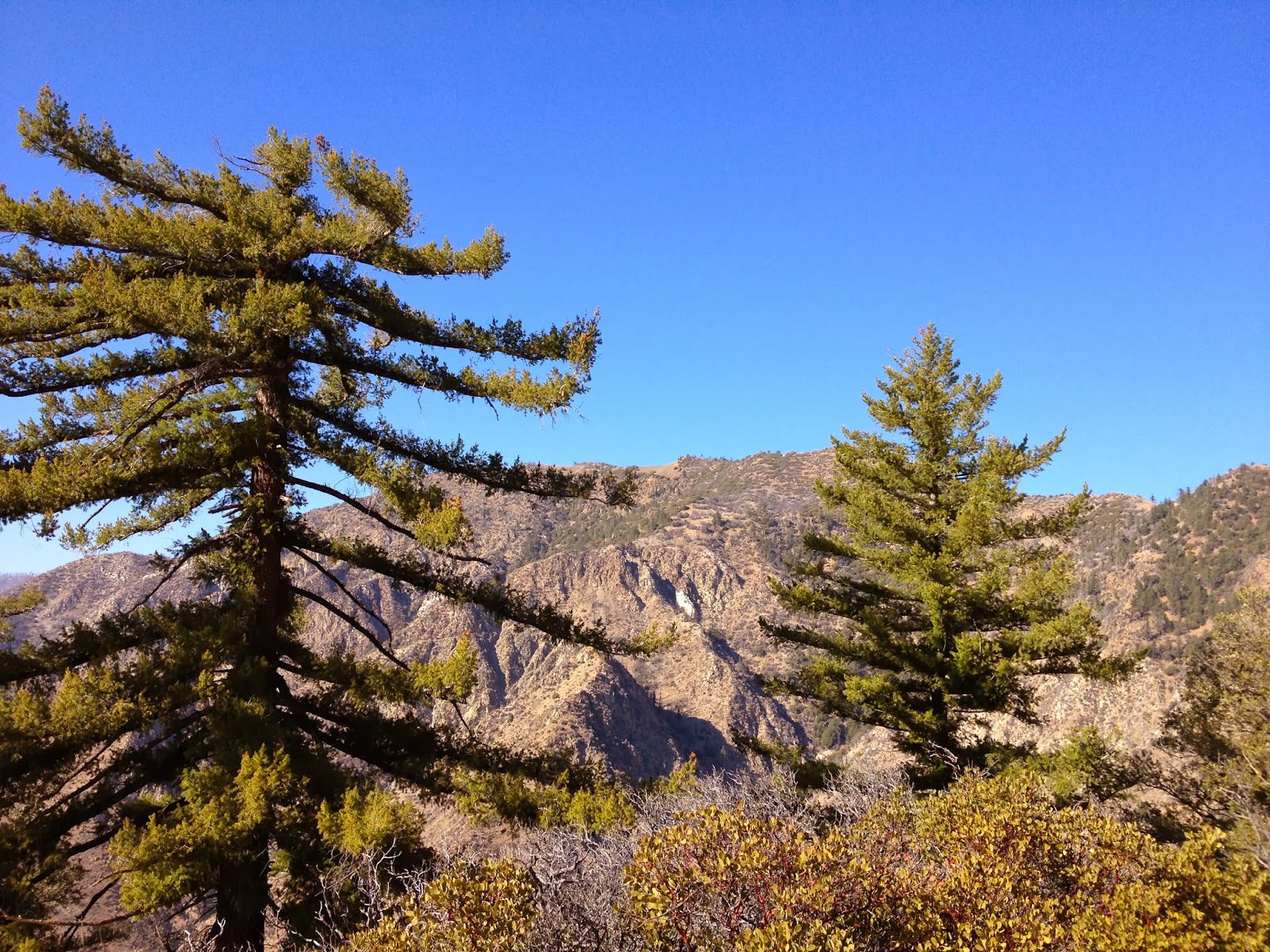
Summit, from the lower ridge.
False summit, from the saddle below The 3 Evils.
The third of The 3 Evils.
Looking at the summit from the east.

At last I topped out. I didn't make a big production out of it and only stayed long enough to take a few photos. I noted that fewer than a dozen people had summited since Nico and I had in spring of 2012 (TR). Jeff Cannon had been there twice by two different lines. Not a popular peak. Hard country.


This climb takes some strategy. I was very disciplined about my approach to this one, as I am with any of the more brutal days I've put down in the mountains (Brutal means different things to different folks. It's all relative. This mountain is a brute.) I took only two real breaks during the entire day, 20 minutes on the summit and 20 minutes on the return leg back at Agua Blanca Creek. All other stops were held to under three minutes, just to blow and shake out. I used a lot of water, understatement. I used every trick I know of for staying motivated and physically on top, and was even better prepared for this go around than I had been on Valentines Day. This is a big day to swallow all at once, but it could reasonably be done with a fresh start from Ant Camp, meaning as an overnight. Despite what you may think, I truly loved this climb. Must be the masochist in me.


The lower aspect of Redrum Ridge.
Looking back down Redrum Ridge.
A view down the ridge from atop the first Evil

Here are my times start to finish. I was surprised by these numbers given the scope of the day.

Gate to ABCreek 2:15
AB-Summit 3:50/6:05
Summit-ABCreek 2:25/8:30
ABCreek-Gate 2:40/10:45 
GPS had it as nearly 26 miles on the day.


Tuesday, March 13, 2012

The Ojai Triple Crown, a 28 mile masochistic odyssey


Welcome to the 2nd (apparently) Annual Ojai Triple Crown. Take Hines Peak, Topa Topa Peak, and Chief Peak, and do 'em all in a day. Here's the stats, and I'll fill in more below:
Miles:  28.9
Elevation gain for the day:  >7,000 feet
Time from start to finish:  12:40

I start walking at 04:30, an hour made even more distasteful by the time change. It is cool and very dark. Patches of luminous moonlight filter through the trees overhead, but the trail remains a black tunnel extending before me. My headlamp is not necessary, but I employ it anyway. The last several times out I've seen cat tracks and this is on my mind in this darkest hour before dawn. Cat eyes reflect light, thus the headlamp. I feel I am moving at a glacial pace, easing through a black world of small rustles and faint breezes. My surgically enhanced night-vision is voided by the headlamp. Every few minutes I pull a "Crazy Ivan", check my six, sweep my backtrail and the surrounding forest with the light, sometimes stopping just to listen. This is not paranoia, this is prudence.
Last year, on the inaugural slog, I didn't quite know how I would feel or how long the day would take, and as a result, I was more concerned with time. I prosecuted it like a war. On that occasion, I felt like I did myself a disservice, like I rushed the day and consequently paid for it in post hike shin-splints and fatigue. Today I choose not to worry about it. I note only the main points, the start and end times and the summits. I strictly ignore my watch for the rest of the day. Time doesn't matter. I concentrate on efficiency, taking constant systems readings, fine tuning my gait, focused entirely on how I feel. I realize that, if I do this "wrong" I could be paying for days afterward. However it turns out, I have to be able to work tomorrow. There is a real world and today I walk it's trails, for tomorrow I pay it's bills in an alternate, less enjoyable reality.

Above and below, Chief Peak at sunrise.

I shiver for a moment in the dark hollow of White Ledge. So far I am feeling this. This crazy thing I've set out to do. I strap into my pack and tackle the stretch before me. Some time later I take off the headlamp and restore my knife to it's usual location on a back pocket ( I had had it clipped to a glove). I'm warmed up now and my pace feels normal for me and, though I don't care, I am sure that I'm already an hour behind last year's time. I pause for a moment under Topa to stash Gatoraid and a PB &J sandwich. No sense carrying these items up Hines if I'm just coming back this way in a few hours. I leave a similar cache at the saddle that separates the two peaks. I am in the weak morning sunlight now. Hines peak is obstructed from view by a lesser hill but that is where I aim myself and that is what I'll climb.

The moon sets on the flank of Topa Topa.

As the miles unfold before me, and Hines Peak gets larger in the windshield, my mind travels down various paths of it's own. I am in synch with myself and my environment. Things are clicking now. Samadhi. My life's true soundtrack sings to me, the crunch of soft footsteps and the whisper of a breeze in my ear. The trail is a lonely space, a laser line through my immediate universe. Where it leads, I go. Soon I stand before the steep slope of Hines. I imagine myself on that unremarkable summit of sticks and stones. I will myself there and I am.

An ancient bit of detritus, found on Hines.
I sign the log atop Hines for the nth time and remind myself that this place needs a new summit journal. The sun is higher now, but brings little warmth. The Stillman apparatus is running at all systems nominal. I note the time in my journal and exit the peak. On the trail again, my mind wanders it's myriad planes while the legs pump and the eyes rove. I retrieve my cache No.1 and move south toward the summit of Topa. Three crows pinwheel across the summit as I roll up to the stone bench. They call to one another as they swoop and dive. I am not alone here. I ingest the contents of my cache, converting carbohydrates and protein into glucose. Installing fresh reactor rods. I take in the view, which, given today's aims, is somewhat dispiriting. The conical summit of Chief Peak is so very far away. The chance to turn back, to call it a day and be self-satisfied, to retreat, lies just below. So easy to return the way I came and stop this madness before someone gets hurt. Clearly I have sat upon this bald summit long enough. My mind is trying to kill me.

A look back towards Topa taken from afar.
Regulation Time Out. Topa Topa.
Rehydrating the organism. Chief Peak.

As I descend Topa the breeze stiffens and my crows are kiting away. It is just me and the winding vagaries of the Nordoff Ridge. I retrieve my second cache of food and fluids. The miles unwind below me. I am well into this now, having long since passed any egress that would allow an easy out. I pass the radio towers, and a little later I turn a blind eye to the junction pointing down Sisar Rd and Horn Canyon. I will be there soon enough, yet there remains business to conduct. The way lies west now, across the great, looping turns of the road. Chief is before me now, seperated from me by a deep cleft. The road continues it's inane series of twists and turns, doubling the distance between me and my omega point, the zenith, the last of the up. I soon stand below the ragged scar which ascends Chief's southern ridge. Soon after I stand above it looking down, down to the Ojai Valley which is obscured in a gauzy haze of moisture. I enjoy my break on the summit. I realize that I feel remarkably good. I have benefited from a disciplined approach to water and calories, reaping the rewards of experience. Many more miles to go, though, before my distant terminus.


My friends, the crows, have returned to honor me with their croaking seranade. My mind again wanders where it will while I trudge down the long slope. The crows have now startled a large red tailed hawk and are harrying her across the sky. I am descending quickly now. I pop my ears. The trail wends its rocky route and I follow. Down low, less that a mile from the truck, I encounter the first humans of the day.  I catch their scent, smell their shampoo and deodorant long before I see them. They are loud and shuffling creatures, enjoying their brief foray into the woods. They are entirely oblivious to my presence until I am already upon them. I see them through cat's eyes. They behave like prey. They are those who do not see and cannot hear.

Here's what helped cut the mustard:
Water {3.75 Litres}
Gatoraid {1 Litre}
5 Hour Energy {2}
PB & J Sandwiches {2}
Tiger Milk Bars {2}
Cliff Bar {1}
GU or Accel Gels {6}
Advil {1600mg)
and as always, everything I would need to survive for 24 hours if I had to.
By the way, that whole "not looking at the clock" thing paid off. I knocked 20 minutes off the last time I did this, probably because I wasn't even trying to. And by the way, I feel capital.

Saturday, April 17, 2010

Hines Peak & Topatopa Bluffs... I hurt.

After a couple of stressful weeks I needed to get outside, and I decided to do something hard. You know, one of those really desperate goals that you never seriously consider doing. By the end of it all I had hiked 22 miles and gained around 6,000ft. This is the only time of year that one can really push on the peak trails of the Los Padres. In another month all those long trails will be very exposed to the sun and the temperatures will soar. At that point I will most likely be found in the Matilija and other local watersheds.
Yesterday was perfect for a masochistic trek with cool breezes and mild temps. A couple of weeks ago I summited Santa Paula Peak, and a couple weeks before that, Topa Topa with the Geezers. Hines is a whole other animal. I have come to the realization that, by peak-bagging standards, Topa Topa is actually a nice, moderate hike. I started at 07:30 from Sesar Road and ground out the miles through White Ledge and up to the Red Reef. Up on the ridge, instead of finishing the Topa Topa summit stretch I kept to the road heading east past the tank trap. This trail was nearly overgrown prior to the Day Fire but is now wide open.
At the saddle behind Topa Topa, Hines Peak isn't quite visible and I was a bit dismayed by how far the final two miles to the Lady Bug/Sespe junction seemed. Basically this was new territory for me and being solo, I immediately realized the potential for serious problems if I were immobilized. This is something that always concerns me when I'm on unfamiliar ground by myself. I think of it as a healthy paranoia. I mentally hunkered down, put one foot in front of another, and started up the steep summit ridge to the top of Hines. At times this ridge pushes a 40 degree scramble and I spent much of it kicking steps in snow. Finally, the summit, and not a very interesting one. There is no USGS marker, no register, no comfortable place to collapse, just some brush and loose rock. The views of the back-country are far superior to those from Topa. Looking north and east is like staring at a topo map of the Sespe, though the distances and the severity of the terrain are amplified. I know that sounds dumb, but you weren't there.
After carefully picking my way down Hines I backtracked toward Topa Topa. Arriving at the summit I dropped into the lounger and just kinda let my brain go for a bit. I just sat there for a while before I was able to pull myself together enough to change my socks, eat something, and give serious thought to the next 7 miles of knee banging downhill. I nearly forgot to sign the register, my 17th entry. As I stepped off the summit I devoted all of my attention making the most of my trekking poles and putting my feet down carefully. When I am worn out my joints get a little loose and it's far easier for me to turn an ankle or make dumb mistakes. Nothing makes for a bad day like a sprained ankle.
After a long break at White Ledge I continued down, down, down. Somewhere along the way I drifted into a zone of semi-awareness. A state where I wasn't paying particular attention any one thing except putting one foot down, then the next...repeat process. I wasn't quite out of gas but I was on reserve. Back on the fire road I ran into Lenore (lattelenore.blogspot.com/) and Cheryl and a friend. They've been banging away at the local trails in preparation for a run up Mt Whitney in July. I don't really recall much of the conversation because I was running on fumes but they're nice people, I'm sure they'll understand. Soon I was back at the truck.

Stats for the day: 8.5 hours Sesar>Hines>Topa Topa>Sesar; greater than 6,00 feet of elevation gained, and 22 honest miles.