Showing posts with label Gene Marshall Trail. Show all posts

Thursday, November 28, 2013

Beartrap Canyon, 11/27/13

Upper Reyes Camp

The following are photos are from the Upper Reyes Creek drainage, the high-country between Reyes Canyons and Beartrap Canyon, and the Beartrap Canyon drainage. I spent the day exploring several of the side drainages coming off the north side of Reyes-Haddock Ridge, which feed into the uppermost portion of Beartrap Creek. It was a beautiful day for some off-trail exploring in a quiet stretch of lonely wilderness. And a beautiful place to spend some time. -DS

Upper Reyes Creek


A drainage that feeds Eastern Beartrap Creek.


East Beartrap Creek


Gene Marshal Piedra Blanca Trail.
The Cuyama Badlands, Mt Abel and Mt Pinos.
Reyes and Haddock Peak from Hwy 33
The coast from Hwy 33


Wednesday, April 24, 2013

Cedar Peak [SVS], 04/23/13

There's a certain kind of person who is compulsively driven to go where few travel. Several years back, a bloke I'll refer to as KC started collecting particularly remote and troublesome peaks that nobody else in our forest even knew how to approach. This gentleman left his SVS mark on some very unique and challenging peaks, and Cedar is one of four of these summits that I've hit. The first time I encountered one of his registers I saw the SVS thing and thought, "Now, what could this be about?". I've since learned that SVS stands for "Seldom Visited Summit", and when you see these letters on a summit register in the Southern Los Padres it means you worked your ass off to get there. These peaks don't have trails, it's up to you to figure it out... and I think that's great. So KC, if you read this I'm drawing a complete blank in my hunt for the final two (I was certain that there would've been one on Devils Heart) and just a hint would be nice. And I like your taste in peaks.

The most sensible way to reach Cedar Peak is to walk up the beautifully forested Cedar Creek until it's time to leave the trail for the summit. Unfortunately, the trailhead for Cedar Creek lies within the Grade Valley/Mutau part of the SLP, and the USFS seldom opens Grade Valley Rd before Memorial Day. Another way for crazy people (Jiroch, KC) to get here is by traversing the crest northwest from Thorn Point. That route looks entertaining. And then there's the way I went, straight the hell up from the Gene Marshall Trail.


I took off from the Sespe/Piedra Blanca Trailhead at 6am. It was a cool and gusty morning, cold enough for gloves. I crossed the desperately low Sespe and turned up the Gene Marshall, headed into Piedra Blanca rocks as the eastern sky was lightening. An atmospheric haze washed out the morning colors and as I descended the north side of PB rocks and turned upstream I was greeted with a persistent blast of wind that gusted down the Piedra Blanca drainage. I made good time and soon passed Piedra Blanca camp and a couple minutes later I took a time out at Twin Forks to charge up before tackling the gnarly climb up to Pine Mountain Lodge.

I put my head down and paced out the 2,400ft climb out of Twin Forks. I somehow managed to pick a pace which I was able to hold the entire way to Pine Mountain Lodge. Not one stop, not even for a minute. This is a hell of a hill, good training for whatever makes you feel good. Before long I was cooling off in a stiff breeze, enjoying the sounds of the wind in the cedars. As I rolled into Pine Mountain Lodge I breathed in the scent of pine and cedar and purely clean air. I was back in the high country and loving it.


After a nice break at Pine Mountain Lodge I picked up the Cedar Creek Trail and settled in for the next mile of uphill. I hadn't yet walked this portion of the Cedar trail and was curious what I was in for. This mile climbed through a beautifully forested ravine, passing between large sandstone formations while rising to a saddle. The Cedar Creek trail continues east over the saddle and descends into that even prettier drainage. From the saddle I turned SSE, climbing a poorly defined ridge through brush and forest. 


After some initial route finding I picked up a poor excuse for a use trail. The most recent traveller on this "path" was a big bear, the same bear I'd followed up the hill from Pine Mtn Lodge. This path wended through manzanita and deadfalls, cedars and pine. The ridge line dropped a couple times before a last, steep and rocky scramble to a bald summit. I rolled up on the summit and paced a wide circle around the peak, taking in all those familiar landmarks from this new perspective. I enjoyed reading the very brief list familiar names in the SVS summit register. The last visitor had been KC himself, in September of 2010. "Seldom Visited" is right!


Click the image bigger to see Thorn Point Fire Lookout, from Cedar Peak.


After some time on summit I descended back toward PM Lodge, taking time to explore some of the caves and overhangs on the numerous rock formations. Done poking around I finished the walk down to the camp and took a nice, long break in the shade. A half hour later I got going again, certainly not looking forward to the long and punishing down grade back to PB. 


Cool rock formations along the Cedar Creek trail. Reyes Peak in the distance.


This is all the water you get at Pine Mtn Lodge.
I basically blasted out of that place, trotting and jogging the whole way out. Just as I crossed the Sespe I saw a big and beautiful grey fox, kind of the icing on this day's cake.


The Rain Rock at Twin Forks needs a better view.


Here's the way the day went. Starting at 06:00 I reached Pine Mountain Lodge at 09:15, and summited at 11:05 (5:05). Was back at the trailhead at 15:40 for 9:40 on the day. That's not too far off what I thought it would be, considering that there's 5,000 feet of gain and loss on this 16.5 mile day. 


Sunday, March 3, 2013

A perfect afternoon on the Gene Marshall Trail. 03/01/13

What a gorgeous day for a mellow walk up the Gene Marshall. Ruth and I woke late and enjoyed our coffee in the back yard under crystal clear blue skies. It was the kind of morning that people move to Southern California for, and I just basked in it, book in hand. Obviously, such a day is not meant to be spent entirely in blissful sloth. So around 10:00 we got off our butts and drove up to Rose Valley for a sunny day stroll.

We meandered up trail through Las Piedras Blanca, the bizarrely weathered extrusions of glaring white sandstone for which the area is named. We followed the route through formations and descended into the Piedra Blanca drainage. This is a super mellow walk and we just kind of ambled along in the sun, enjoying being out, together.

Before long we arrived at Piedra Blanca Camp. This sweet little spot on the creek is shaded by the massive arbors of ancient oaks. On one of the rocks near the camp one can spot the two pictographs shown above. We dropped our pack and pulled out a simple lunch of fruit and nuts with cheese. The sound of the warm spring breeze whispering through the old oaks combined with the pleasant burbling of the nearby creek, lulling me into a post-lunch sedation. We stayed there, under the oaks, for quite a while before heading back the way we'd come. Nice little 5 mile walk and the perfect day for it.
  
PB Camp.
PB Camp.
Piedra Blanca Creek from just above PB Camp.


Las Piedras Blanca
Sespe Creek.
Sespe Creek.

Thursday, February 16, 2012

A long and poorly produced video from Gene Marshall Trail

Like I say, it may not be worth watching but the video does show you some of what parts of the trail are like.  I'm gettin' better at this. As Bad Santa (Bill Bob Thornton) said, "They can't all be winners, now can they?".

David Stillman & Cliff Griffiths on the Gene Marshall Trail, Feb 2012

Tuesday, February 14, 2012

Gene Marshall Trail 1 day. Tough.


This is my new favorite Los Padres trail of all time. The Gene Marshall trail, all 19 grueling miles of it, provides the most comprehensive exposure to the wonders of our region that can be crammed into a single route. This walk has it all: high cedar forests, creeks, meadows, valleys, wildlife, snow, desert, Chumash rock art, more than 30 creek crossings, very remote wilderness, ever present bear sign, cat tracks, epic vistas...about the only thing missing is a sulfury hot spring. 


 Above: The first cat prints of the day came early and often.

Cliff Griffiths and I met bumpers at the Deer Lodge on 33 at 05:00 on Sunday. From there, we dropped his truck at the Piedra Blanca trailhead and drove my pick-up over Pine Mountain and into Scheidek where we parked at the Reyes Creek trailhead. We saddled up and started walking in the frozen, pre-dawn light at 06:05. It was a great start to what turned out to be an truly amazing day.

I should get one disclaimer out of the way...this is not a day hike. I want to be clear that this is more than most people can do in a day, and careful consideration should go into attempting to do this route all at once. This is true wilderness, not the place for "scenic walk". Having said that,  if we look at the map, the numbers don't look too bad. That is a lie. The map suggests that the first 9 or so miles from Reyes Creek trailhead is a more or less gentle, but consistent climb of about 2,500', the high point being Haddock Camp at 6165'. The real story is this: the Gene Marshall basically transits through a series of small valleys. Every 2-3 miles the hiker has to descend into, cut through, and then climb out of a valley, clear a saddle, and repeat process. There is a lot of shifting gears between climbing and descending, and any experienced hiker can tell you that those change-ups tend to drain your batteries.


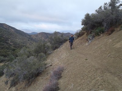
Our morning was cold and clear, the three-quarter moon hanging above Reyes Peak. We walked on the paths of the Old Ones. Many parts of this trail make almost too much sense, in terms of efficient travel. The route is obviously old, a highway connecting Rose Valley and the ocean to the coastal interior. We blazed through valleys full of cedar and poderosa, old oak forests waking to the birds greeting the dawn. High above our heads, arctic winds and scattered clouds frosted the Pine Mountain Ridge. Cliff and I wondered just how soon we'd be in that freezing mess, but we needn't have worried. The route stays low, sliding from one valley to the next. By mid-morning we were deep into the wilds.
  
Cliff and I both moved fairly quickly. The path is, in most cases, easy to follow. We had two moments of  route finding difficulty, quickly resolved.  The trail was largely smooth, and most of the day we walked on a springy loam of decomposing bio-mass (leaves). Crossing animal tracks and scat became routine. The place felt very wild, wildernessy. After the first mile we saw no tracks of man or horse for the next twelve. This is the high rugged country. Cliff remarked that it reminded him of the area around Bass Lake near Yosemite and I concurred. High and dry with the ever present scent of pine. We both agreed that, by the end of the day we had crossed over water at minimum, 35 times. This dry winter worked well for us yesterday, water levels were low and consequently we were able to keep "feet dry" all day. It was very pleasant to hear the bubbling sounds of a small creek nearby. No, I didn't eat shit in a creek, which is sort of my SOP.
Over the saddle from Reyes Canyon, headed down towards Beartrap.
Miles of cedar forest.
One of the nicer features along the stretch of this trail is the placement of campsites. We started comparing it to the California Mission System. From our direction we passed through: Reyes, Beartrap, Haddock, Three Mile, Pine Mtn Lodge, Twin Forks and Piedra Blanca camps. These camps are 2-5 miles apart and they became the next logical pit-stop as we trudged the long miles. 3 Mile camp is a pretty sweet little spot.

For miles, it seemed, the only evidence of man was an ancient trail shrouded in leaves.
Remarkably good signage along the route, though very few use the trail.
Cliff looked down and found this 1934 quarter at Haddock Camp.

Above and Below: Momma Lion and cub. Mom has a 5" foot which would probably put her at 100-115 lbs. Healthy. We followed her prints for over 6 miles. She would intermittently depart the trail but for the most part, we walked in her steps. We figured that she observed us. We also figured that she'd be making sure that we never saw her or her kitten. These tracks weren't new, but had definitely been made sometime in the last day. Mom's with kittens don't travel far unless they are driven from the den site. She was out there watching, somewhere. A surfer would say it felt "sharky".
 
Above: The Chumash pictographs of Piedra Blanca Creek. We added 45 minutes to the day to reach these.

Cliff, making it back into the sun. The day never did warm up.
0.8 miles from the truck. Then 45 minutes back to my truck. Then an hour and 15 to get home, except that right in front of me Cliff has stopped. This is because there are numerous emergency vehicles and a sheriff's department helicopter, rotor turning, stopped on Highway 33. We were told that a motorcyclist had just had a very bad day. I got the chopper on video, which I'll post soon.

This was one of the most fulfilling days I've experienced in the Los Padres. Not only was the journey long, the route tough, and the effort legit, but the route was beautiful, remote, rugged. Over every saddle lay a new valley, it's own distinct place. Different from the last, yet familiar. I felt like I was in an environment that required and rewarded the alert, and the watchful. The constant cat tracks and the copious piles of bear shit made daydreaming an activity for the foolish. The area had a vibe, ageless yet old.  For all this and everything I can't put into words, I rate this a 5 Star Trail. And a word of admiration for Cliff, the guy is fit and has the stamina to just go on. He don't quit easy. Comrade Cliff, a good one for the trail.  
Trip time with breaks: 9.5 hrs